Karlovac elevation
Karlovac (Karlovačka, Grad Karlovac), Croatia elevation is 114 meters and Karlovac elevation in feet is 374 ft above sea level [src 1]. Karlovac is a seat of a first-order administrative division (feature code) with elevation that is 40 meters (131 ft) smaller than average city elevation in Croatia.
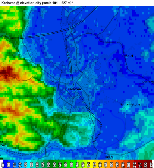
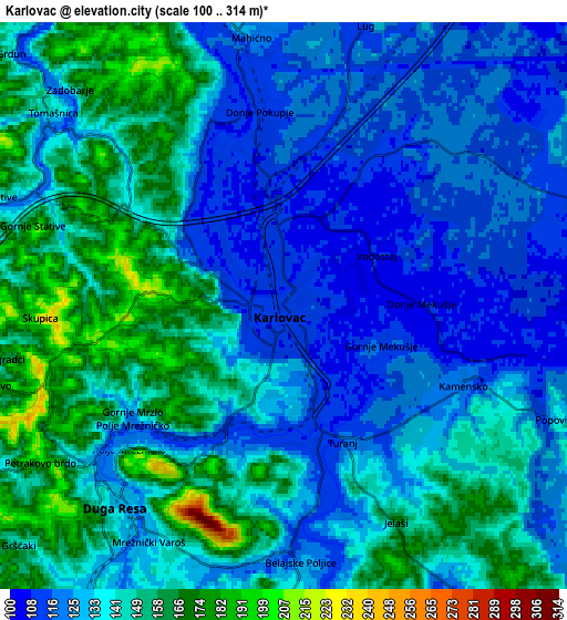
Below is the Elevation map of Karlovac, which displays elevation range with different colors. Scale of the first map is from 101 to 227 m (331 to 745 ft) with average elevation of 124.2 meters (=407 ft) [note 1]
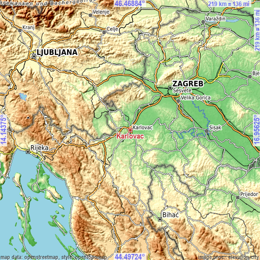
These maps also provides idea of topography and contour of this city, they are displayed at different zoom levels. More info about maps, scale and edge coordinates you can find below images.
| \ | Map #1 | Map #2 | Topo.Map |
| Scale [m] | 101..227 m | 100..314 m | × |
| Scale [ft] | 331..745 ft | 328..1030 ft | × |
| Average | 124.2 m = 407 ft | 137.2 m = 450 ft | × |
| Width | 6.85 km = 4.3 mi | 13.7 km = 8.5 mi | 219.2 km = 136.2 mi |
| Height | 6.85 km = 4.3 mi | 13.7 km = 8.5 mi | 219.2 km = 136.2 mi |
| ↑Max Latitude | 45.522468° | 45.553249° | 46.46884° |
| Latitude at center | 45.49167° | 45.49167° | 45.49167° |
| ↓Min Latitude | 45.460855° | 45.430024° | 44.49724° |
| ← Min Longitude | 15.506055° | 15.462109° | 14.14375° |
| Longitude center | 15.55° | 15.55° | 15.55° |
| →Max Longitude | 15.593945° | 15.637891° | 16.95625° |
Nearby cities:
Cities around Karlovac sort by population:
• Jastrebarsko elevation 142 m
21.1 km,  21°
21°
• Ozalj 197 m
14.5 km,  331°
331°
• Generalski Stol 200 m
20.6 km,  219°
219°
• Kamanje 167 m
20 km,  323°
323°
• Žakanje 204 m
19.7 km,  307°
307°
• Krašić 150 m
18.4 km,  352°
352°
• Ribnik 151 m
18.3 km,  302°
302°
• Krnjak 140 m
18 km,  167°
167°
• Draganići 132 m
12.7 km, 17°
• Barilović 134 m
12 km,  180°
180°
• Netretić 266 m
10.8 km,  280°
280°
• Duga Resa 128 m
8.5 km,  214°
214°
Multilingual:
 En español:
Karlovac elevación 114 m.
 En France:
Karlovac élévation 114 m.
 Auf Deutsch:
Karlovac höhe über dem Meeresspiegel ist 114 m.

Sources and notes:
- [note 1] Map square and city borders are not equal. Map elevation data is calculated only from area inside that square.
- [src 1] Elevation data from geonames database provided with same terms of usage.
- [src 2] The elevation map of Karlovac is generated using elevation data from NASA's 3 arcsec (90m) resolution SRTM data.
- [src 3] Base (background) map © OpenStreetMap contributors tiles are generated by Geofabrik and OpenTopoMap.
Copyright & License:
This Karlovac Elevation Map is licensed under CC BY-SA. You may reuse any part from this page, if you give a proper credit by linking to this URL:
 More info on terms of use page.