Krašić elevation
Krašić (Zagrebačka), Croatia elevation is 150 meters and Krašić elevation in feet is 492 ft above sea level [src 1]. Krašić is a seat of a second-order administrative division (feature code) with elevation that is 4 meters (13 ft) smaller than average city elevation in Croatia.
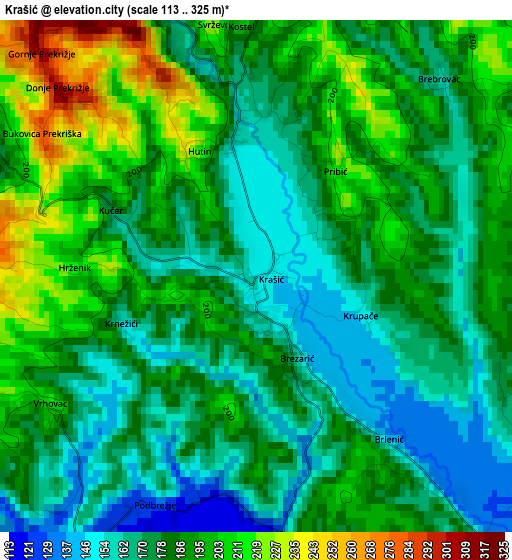
Below is the Elevation map of Krašić, which displays elevation range with different colors. Scale of the first map is from 113 to 325 m (371 to 1066 ft) with average elevation of 182.7 meters (=599 ft) [note 1]
These maps also provides idea of topography and contour of this city, they are displayed at different zoom levels. More info about maps, scale and edge coordinates you can find below images.
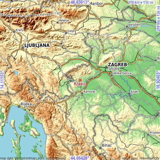
| \ | Map #1 | Topo.Map |
| Scale [m] | 113..325 m | × |
| Scale [ft] | 371..1066 ft | × |
| Average | 182.7 m = 599 ft | × |
| Width | 6.83 km = 4.2 mi | 218.6 km = 135.8 mi |
| Height | 6.83 km = 4.2 mi | 218.6 km = 135.8 mi |
| ↑Max Latitude | 45.686538° | 46.63013° |
| Latitude at center | 45.65583° | 45.65583° |
| ↓Min Latitude | 45.625105° | 44.66428° |
| ← Min Longitude | 15.473835° | 14.11153° |
| Longitude center | 15.51778° | 15.51778° |
| →Max Longitude | 15.561725° | 16.92403° |
Nearby cities:
Cities around Krašić sort by population:
• Karlovac elevation 114 m
18.4 km,  172°
172°
• Jastrebarsko 142 m
10.3 km,  82°
82°
• Ozalj 197 m
7 km,  218°
218°
• Rude 392 m
16.9 km,  43°
43°
• Donja Zdenčina 121 m
19.4 km,  86°
86°
• Netretić 266 m
18.2 km,  206°
206°
• Klinča Sela 145 m
17.8 km, 77°
• Ribnik 151 m
15.5 km,  236°
236°
• Žakanje 204 m
14.4 km, 244°
• Žumberak 453 m
12.4 km,  327°
327°
• Kamanje 167 m
9.8 km,  256°
256°
• Draganići 132 m
8.9 km,  134°
134°
Multilingual:
 En español:
Krašić elevación 150 m.
 En France:
Krašić élévation 150 m.


Sources and notes:
- [note 1] Map square and city borders are not equal. Map elevation data is calculated only from area inside that square.
- [src 1] Elevation data from geonames database provided with same terms of usage.
- [src 2] The elevation map of Krašić is generated using elevation data from NASA's 3 arcsec (90m) resolution SRTM data.
- [src 3] Base (background) map © OpenStreetMap contributors tiles are generated by Geofabrik and OpenTopoMap.
Copyright & License:
This Krašić Elevation Map is licensed under CC BY-SA. You may reuse any part from this page, if you give a proper credit by linking to this URL:
 More info on terms of use page.