Podgora elevation
Podgora (Dubrovačko-Neretvanska, Dubrovačko primorje), Croatia elevation is 249 meters and Podgora elevation in feet is 817 ft above sea level [src 1]. Podgora is a populated locality (feature code) with elevation that is 95 meters (312 ft) bigger than average city elevation in Croatia.
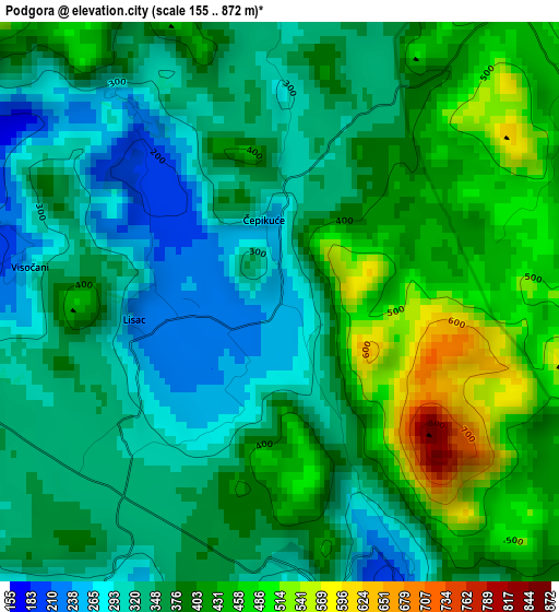
Below is the Elevation map of Podgora, which displays elevation range with different colors. Scale of the first map is from 155 to 872 m (509 to 2861 ft) with average elevation of 377.4 meters (=1238 ft) [note 1]
These maps also provides idea of topography and contour of this city, they are displayed at different zoom levels. More info about maps, scale and edge coordinates you can find below images.
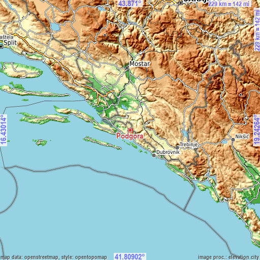
| \ | Map #1 | Topo.Map |
| Scale [m] | 155..872 m | × |
| Scale [ft] | 509..2861 ft | × |
| Average | 377.4 m = 1238 ft | × |
| Width | 7.16 km = 4.4 mi | 229.3 km = 142.5 mi |
| Height | 7.16 km = 4.4 mi | 229.3 km = 142.5 mi |
| ↑Max Latitude | 42.88082° | 43.871° |
| Latitude at center | 42.84861° | 42.84861° |
| ↓Min Latitude | 42.816383° | 41.80902° |
| ← Min Longitude | 17.792445° | 16.43014° |
| Longitude center | 17.83639° | 17.83639° |
| →Max Longitude | 17.880335° | 19.24264° |
Nearby cities:
Cities around Podgora sort by population:
• Dubrovnik elevation 52 m
30.6 km,  136°
136°
• Metković 5 m
27.5 km,  326°
326°
• Blato 50 m
30.4 km,  251°
251°
• Ston 4 m
11.5 km,  264°
264°
• Opuzen 1 m
28.8 km,  310°
310°
• Mokošica 16 m
28.3 km,  132°
132°
• Komin 5 m
32.4 km, 311°
• Janjina 120 m
34.3 km,  284°
284°
• Vlaka 0 m
30.4 km,  303°
303°
• Kula Norinska 25 m
27.7 km,  317°
317°
• Babino Polje 158 m
25.8 km,  240°
240°
• Slano 8 m
8.3 km,  146°
146°
Multilingual:
 En español:
Podgora elevación 249 m.
 En France:
Podgora élévation 249 m.


Sources and notes:
- [note 1] Map square and city borders are not equal. Map elevation data is calculated only from area inside that square.
- [src 1] Elevation data from geonames database provided with same terms of usage.
- [src 2] The elevation map of Podgora is generated using elevation data from NASA's 3 arcsec (90m) resolution SRTM data.
- [src 3] Base (background) map © OpenStreetMap contributors tiles are generated by Geofabrik and OpenTopoMap.
Copyright & License:
This Podgora Elevation Map is licensed under CC BY-SA. You may reuse any part from this page, if you give a proper credit by linking to this URL:
 More info on terms of use page.