Čazma elevation
Čazma (Bjelovarsko-Bilogorska, Grad Čazma), Croatia elevation is 138 meters and Čazma elevation in feet is 453 ft above sea level [src 1]. Čazma is a seat of a second-order administrative division (feature code) with elevation that is 16 meters (52 ft) smaller than average city elevation in Croatia.
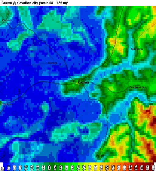
Below is the Elevation map of Čazma, which displays elevation range with different colors. Scale of the first map is from 98 to 186 m (322 to 610 ft) with average elevation of 115.2 meters (=378 ft) [note 1]
These maps also provides idea of topography and contour of this city, they are displayed at different zoom levels. More info about maps, scale and edge coordinates you can find below images.
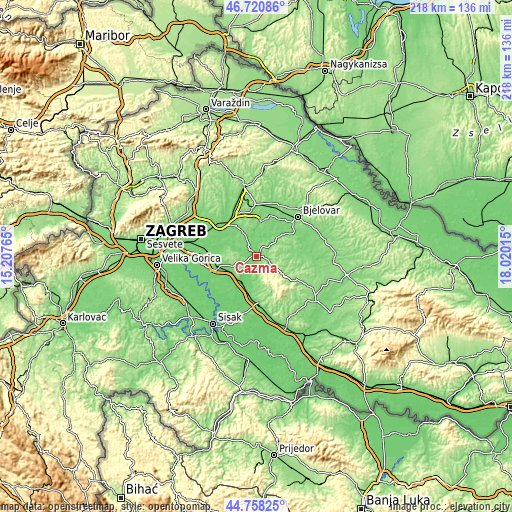
| \ | Map #1 | Topo.Map |
| Scale [m] | 98..186 m | × |
| Scale [ft] | 322..610 ft | × |
| Average | 115.2 m = 378 ft | × |
| Width | 6.82 km = 4.2 mi | 218.2 km = 135.6 mi |
| Height | 6.82 km = 4.2 mi | 218.2 km = 135.6 mi |
| ↑Max Latitude | 45.778837° | 46.72086° |
| Latitude at center | 45.74818° | 45.74818° |
| ↓Min Latitude | 45.717506° | 44.75825° |
| ← Min Longitude | 16.569955° | 15.20765° |
| Longitude center | 16.6139° | 16.6139° |
| →Max Longitude | 16.657845° | 18.02015° |
Nearby cities:
Cities around Čazma sort by population:
• Popovača elevation 127 m
19.9 km,  177°
177°
• Križ 121 m
11.6 km,  217°
217°
• Novoselec 99 m
12.2 km,  209°
209°
• Gudovac 115 m
19.6 km,  41°
41°
• Ivanska 132 m
15.7 km,  77°
77°
• Ivanić-Grad 103 m
17.4 km,  255°
255°
• Berek 148 m
16.8 km,  93°
93°
• Velika Ludina 132 m
16.5 km, 183°
• Kloštar Ivanić 168 m
14.7 km,  266°
266°
• Farkaševac 112 m
14.7 km,  8°
8°
• Dubrava 141 m
11.6 km,  329°
329°
• Štefanje 157 m
10.4 km,  52°
52°
Multilingual:
 En español:
Čazma elevación 138 m.
 En France:
Čazma élévation 138 m.


Sources and notes:
- [note 1] Map square and city borders are not equal. Map elevation data is calculated only from area inside that square.
- [src 1] Elevation data from geonames database provided with same terms of usage.
- [src 2] The elevation map of Čazma is generated using elevation data from NASA's 3 arcsec (90m) resolution SRTM data.
- [src 3] Base (background) map © OpenStreetMap contributors tiles are generated by Geofabrik and OpenTopoMap.
Copyright & License:
This Čazma Elevation Map is licensed under CC BY-SA. You may reuse any part from this page, if you give a proper credit by linking to this URL:
 More info on terms of use page.