Cerovlje elevation
Cerovlje (Istria), Croatia elevation is 294 meters and Cerovlje elevation in feet is 965 ft above sea level [src 1]. Cerovlje is a seat of a second-order administrative division (feature code) with elevation that is 140 meters (459 ft) bigger than average city elevation in Croatia.
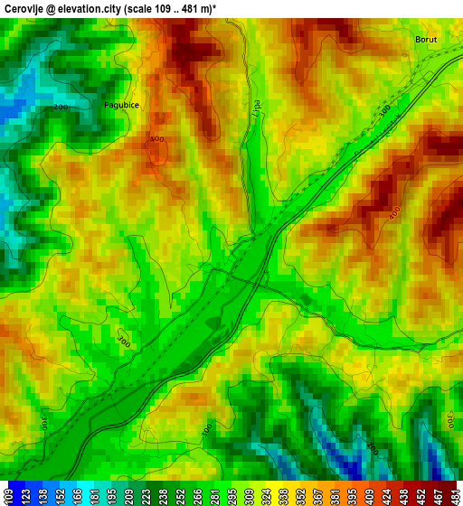
Below is the Elevation map of Cerovlje, which displays elevation range with different colors. Scale of the first map is from 109 to 481 m (358 to 1578 ft) with average elevation of 310.7 meters (=1019 ft) [note 1]
These maps also provides idea of topography and contour of this city, they are displayed at different zoom levels. More info about maps, scale and edge coordinates you can find below images.
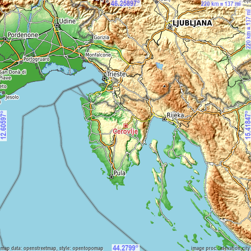
| \ | Map #1 | Topo.Map |
| Scale [m] | 109..481 m | × |
| Scale [ft] | 358..1578 ft | × |
| Average | 310.7 m = 1019 ft | × |
| Width | 6.88 km = 4.3 mi | 220.1 km = 136.8 mi |
| Height | 6.88 km = 4.3 mi | 220 km = 136.7 mi |
| ↑Max Latitude | 45.308974° | 46.25897° |
| Latitude at center | 45.27806° | 45.27806° |
| ↓Min Latitude | 45.247129° | 44.2799° |
| ← Min Longitude | 13.968275° | 12.60597° |
| Longitude center | 14.01222° | 14.01222° |
| →Max Longitude | 14.056165° | 15.41847° |
Nearby cities:
Cities around Cerovlje sort by population:
• Buzet elevation 80 m
15 km,  346°
346°
• Pazin 268 m
7.3 km,  234°
234°
• Karojba 275 m
15 km,  279°
279°
• Žminj 370 m
17.1 km,  208°
208°
• Motovun 270 m
15.8 km,  294°
294°
• Nedeščina 298 m
17.2 km,  153°
153°
• Lanišće 546 m
16.5 km,  29°
29°
• Sveti Petar u Šumi 336 m
15.4 km, 227°
• Kršan 135 m
15.3 km,  139°
139°
• Tinjan 313 m
15.1 km,  243°
243°
• Pićan 296 m
8.4 km,  163°
163°
• Gračišće 443 m
6.6 km,  181°
181°
Multilingual:
 En español:
Cerovlje elevación 294 m.
 En France:
Cerovlje élévation 294 m.
 Auf Deutsch:
Cerovlje höhe über dem Meeresspiegel ist 294 m.

Sources and notes:
- [note 1] Map square and city borders are not equal. Map elevation data is calculated only from area inside that square.
- [src 1] Elevation data from geonames database provided with same terms of usage.
- [src 2] The elevation map of Cerovlje is generated using elevation data from NASA's 3 arcsec (90m) resolution SRTM data.
- [src 3] Base (background) map © OpenStreetMap contributors tiles are generated by Geofabrik and OpenTopoMap.
Copyright & License:
This Cerovlje Elevation Map is licensed under CC BY-SA. You may reuse any part from this page, if you give a proper credit by linking to this URL:
 More info on terms of use page.