Pazin elevation
Pazin (Istria, Grad Pazin), Croatia elevation is 268 meters and Pazin elevation in feet is 879 ft above sea level [src 1]. Pazin is a seat of a first-order administrative division (feature code) with elevation that is 114 meters (374 ft) bigger than average city elevation in Croatia.
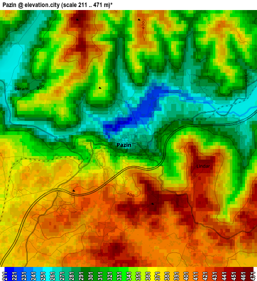
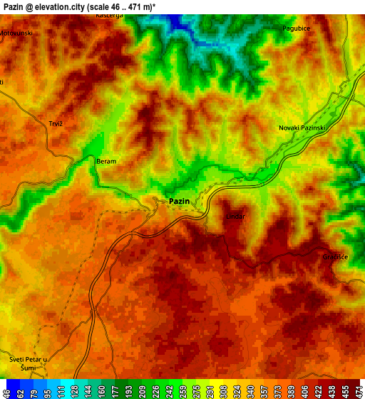
Below is the Elevation map of Pazin, which displays elevation range with different colors. Scale of the first map is from 211 to 471 m (692 to 1545 ft) with average elevation of 351.2 meters (=1152 ft) [note 1]
These maps also provides idea of topography and contour of this city, they are displayed at different zoom levels. More info about maps, scale and edge coordinates you can find below images.
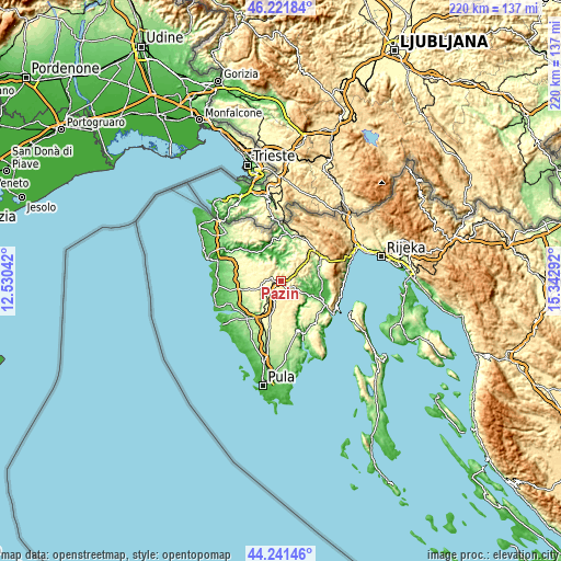
| \ | Map #1 | Map #2 | Topo.Map |
| Scale [m] | 211..471 m | 46..471 m | × |
| Scale [ft] | 692..1545 ft | 151..1545 ft | × |
| Average | 351.2 m = 1152 ft | 346.3 m = 1136 ft | × |
| Width | 6.88 km = 4.3 mi | 13.76 km = 8.6 mi | 220.2 km = 136.8 mi |
| Height | 6.88 km = 4.3 mi | 13.76 km = 8.6 mi | 220.2 km = 136.8 mi |
| ↑Max Latitude | 45.271215° | 45.302133° | 46.22184° |
| Latitude at center | 45.24028° | 45.24028° | 45.24028° |
| ↓Min Latitude | 45.209328° | 45.178359° | 44.24146° |
| ← Min Longitude | 13.892725° | 13.848779° | 12.53042° |
| Longitude center | 13.93667° | 13.93667° | 13.93667° |
| →Max Longitude | 13.980615° | 14.024561° | 15.34292° |
Nearby cities:
Cities around Pazin sort by population:
• Karojba elevation 275 m
11.2 km,  307°
307°
• Žminj 370 m
11.1 km,  191°
191°
• Kanfanar 285 m
15.2 km,  210°
210°
• Motovun 270 m
13.6 km,  321°
321°
• Svetvinčenat 311 m
17.4 km, 193°
• Vižinada 260 m
17.1 km, 305°
• Sveti Lovreč Pazenatički 184 m
16.9 km,  244°
244°
• Pićan 296 m
9.1 km,  114°
114°
• Sveti Petar u Šumi 336 m
8.3 km,  220°
220°
• Tinjan 313 m
8 km,  252°
252°
• Cerovlje 294 m
7.3 km,  54°
54°
• Gračišće 443 m
6.3 km, 112°
Multilingual:
 En español:
Pazin elevación 268 m.
 En France:
Pazin élévation 268 m.


Sources and notes:
- [note 1] Map square and city borders are not equal. Map elevation data is calculated only from area inside that square.
- [src 1] Elevation data from geonames database provided with same terms of usage.
- [src 2] The elevation map of Pazin is generated using elevation data from NASA's 3 arcsec (90m) resolution SRTM data.
- [src 3] Base (background) map © OpenStreetMap contributors tiles are generated by Geofabrik and OpenTopoMap.
Copyright & License:
This Pazin Elevation Map is licensed under CC BY-SA. You may reuse any part from this page, if you give a proper credit by linking to this URL:
 More info on terms of use page.