Glina elevation
Glina (Sisačko-Moslavačka, Grad Glina), Croatia elevation is 112 meters and Glina elevation in feet is 367 ft above sea level [src 1]. Glina is a seat of a second-order administrative division (feature code) with elevation that is 42 meters (138 ft) smaller than average city elevation in Croatia.
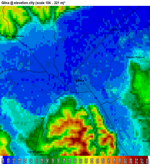
Below is the Elevation map of Glina, which displays elevation range with different colors. Scale of the first map is from 104 to 221 m (341 to 725 ft) with average elevation of 127.6 meters (=419 ft) [note 1]
These maps also provides idea of topography and contour of this city, they are displayed at different zoom levels. More info about maps, scale and edge coordinates you can find below images.
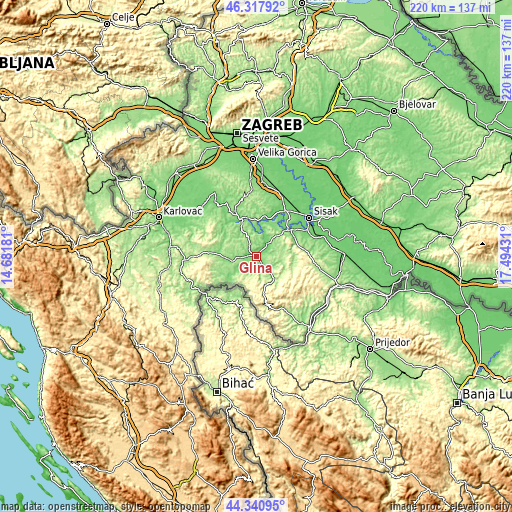
| \ | Map #1 | Topo.Map |
| Scale [m] | 104..221 m | × |
| Scale [ft] | 341..725 ft | × |
| Average | 127.6 m = 419 ft | × |
| Width | 6.87 km = 4.3 mi | 219.8 km = 136.6 mi |
| Height | 6.87 km = 4.3 mi | 219.8 km = 136.6 mi |
| ↑Max Latitude | 45.368942° | 46.31792° |
| Latitude at center | 45.33806° | 45.33806° |
| ↓Min Latitude | 45.307161° | 44.34095° |
| ← Min Longitude | 16.044115° | 14.68181° |
| Longitude center | 16.08806° | 16.08806° |
| →Max Longitude | 16.132005° | 17.49431° |
Nearby cities:
Cities around Glina sort by population:
• Sisak elevation 108 m
26.8 km,  57°
57°
• Petrinja 111 m
19.3 km,  54°
54°
• Lekenik 102 m
29.2 km,  19°
19°
• Budaševo 94 m
31.2 km, 60°
• Gvozd 131 m
17.5 km,  275°
275°
• Vojnić 141 m
30.5 km,  266°
266°
• Pisarovina 136 m
32.9 km,  327°
327°
• Donji Kukuruzari 150 m
31.9 km,  104°
104°
• Lasinja 140 m
27.7 km,  319°
319°
• Kravarsko 206 m
27.4 km,  353°
353°
• Pokupsko 135 m
18.2 km,  335°
335°
• Topusko 119 m
10.3 km,  241°
241°
Multilingual:
 En español:
Glina elevación 112 m.
 En France:
Glina élévation 112 m.


Sources and notes:
- [note 1] Map square and city borders are not equal. Map elevation data is calculated only from area inside that square.
- [src 1] Elevation data from geonames database provided with same terms of usage.
- [src 2] The elevation map of Glina is generated using elevation data from NASA's 3 arcsec (90m) resolution SRTM data.
- [src 3] Base (background) map © OpenStreetMap contributors tiles are generated by Geofabrik and OpenTopoMap.
Copyright & License:
This Glina Elevation Map is licensed under CC BY-SA. You may reuse any part from this page, if you give a proper credit by linking to this URL:
 More info on terms of use page.