Kravarsko elevation
Kravarsko (Zagrebačka), Croatia elevation is 206 meters and Kravarsko elevation in feet is 676 ft above sea level [src 1]. Kravarsko is a seat of a second-order administrative division (feature code) with elevation that is 52 meters (171 ft) bigger than average city elevation in Croatia.
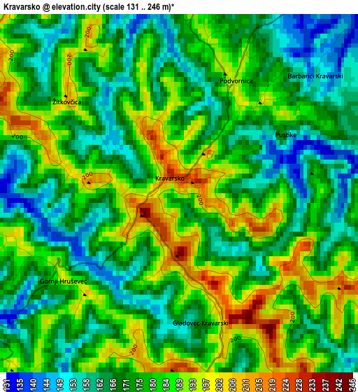
Below is the Elevation map of Kravarsko, which displays elevation range with different colors. Scale of the first map is from 131 to 246 m (430 to 807 ft) with average elevation of 176.4 meters (=579 ft) [note 1]
These maps also provides idea of topography and contour of this city, they are displayed at different zoom levels. More info about maps, scale and edge coordinates you can find below images.
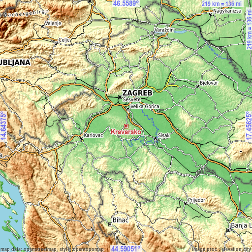
| \ | Map #1 | Topo.Map |
| Scale [m] | 131..246 m | × |
| Scale [ft] | 430..807 ft | × |
| Average | 176.4 m = 579 ft | × |
| Width | 6.84 km = 4.3 mi | 218.9 km = 136 mi |
| Height | 6.84 km = 4.3 mi | 218.9 km = 136 mi |
| ↑Max Latitude | 45.614078° | 46.5589° |
| Latitude at center | 45.58333° | 45.58333° |
| ↓Min Latitude | 45.552566° | 44.59051° |
| ← Min Longitude | 16.006055° | 14.64375° |
| Longitude center | 16.05° | 16.05° |
| →Max Longitude | 16.093945° | 17.45625° |
Nearby cities:
Cities around Kravarsko sort by population:
• Velika Gorica elevation 107 m
14.5 km,  7°
7°
• Lekenik 102 m
12.6 km,  88°
88°
• Gradići 103 m
13 km,  0°
0°
• Donja Lomnica 108 m
14.4 km,  352°
352°
• Odra 113 m
16.9 km,  344°
344°
• Kuče 101 m
12.8 km,  35°
35°
• Novo Čiče 101 m
14 km,  21°
21°
• Lukavec 112 m
14.3 km, 340°
• Mraclin 104 m
9.9 km, 20°
• Lasinja 140 m
16.1 km,  247°
247°
• Pisarovina 136 m
14.9 km,  271°
271°
• Pokupsko 135 m
11.6 km,  202°
202°
Multilingual:
 En español:
Kravarsko elevación 206 m.
 En France:
Kravarsko élévation 206 m.
 Auf Deutsch:
Kravarsko höhe über dem Meeresspiegel ist 206 m.

Sources and notes:
- [note 1] Map square and city borders are not equal. Map elevation data is calculated only from area inside that square.
- [src 1] Elevation data from geonames database provided with same terms of usage.
- [src 2] The elevation map of Kravarsko is generated using elevation data from NASA's 3 arcsec (90m) resolution SRTM data.
- [src 3] Base (background) map © OpenStreetMap contributors tiles are generated by Geofabrik and OpenTopoMap.
Copyright & License:
This Kravarsko Elevation Map is licensed under CC BY-SA. You may reuse any part from this page, if you give a proper credit by linking to this URL:
 More info on terms of use page.