Gunja elevation
Gunja (Vukovar-Sirmium), Croatia elevation is 84 meters and Gunja elevation in feet is 276 ft above sea level [src 1]. Gunja is a seat of a second-order administrative division (feature code) with elevation that is 70 meters (230 ft) smaller than average city elevation in Croatia.
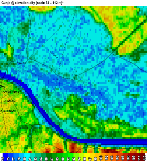
Below is the Elevation map of Gunja, which displays elevation range with different colors. Scale of the first map is from 74 to 112 m (243 to 367 ft) with average elevation of 84.7 meters (=278 ft) [note 1]
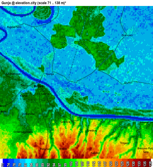
These maps also provides idea of topography and contour of this city, they are displayed at different zoom levels. More info about maps, scale and edge coordinates you can find below images.
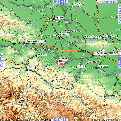
| \ | Map #1 | Map #2 | Topo.Map |
| Scale [m] | 74..112 m | 71..138 m | × |
| Scale [ft] | 243..367 ft | 233..453 ft | × |
| Average | 84.7 m = 278 ft | 90.5 m = 297 ft | × |
| Width | 6.92 km = 4.3 mi | 13.85 km = 8.6 mi | 221.6 km = 137.7 mi |
| Height | 6.92 km = 4.3 mi | 13.85 km = 8.6 mi | 221.6 km = 137.7 mi |
| ↑Max Latitude | 44.911131° | 44.942244° | 45.86782° |
| Latitude at center | 44.88° | 44.88° | 44.88° |
| ↓Min Latitude | 44.848853° | 44.817688° | 43.87492° |
| ← Min Longitude | 18.809385° | 18.765439° | 17.44708° |
| Longitude center | 18.85333° | 18.85333° | 18.85333° |
| →Max Longitude | 18.897275° | 18.941221° | 20.25958° |
Nearby cities:
Cities around Gunja sort by population:
• Županja elevation 81 m
25.1 km,  330°
330°
• Otok 90 m
29.7 km,  4°
4°
• Bošnjaci 82 m
20.4 km,  337°
337°
• Privlaka 81 m
35 km,  357°
357°
• Gradište 85 m
32 km, 338°
• Vrbanja 80 m
12.7 km,  27°
27°
• Štitar 82 m
29.2 km, 325°
• Nijemci 86 m
32.3 km, 26°
• Komletinci 88 m
30.9 km,  14°
14°
• Soljani 81 m
12.1 km,  49°
49°
• Drenovci 83 m
6.5 km, 45°
• Slavonski Šamac 83 m
35.4 km,  305°
305°
Multilingual:
 En español:
Gunja elevación 84 m.
 En France:
Gunja élévation 84 m.


Sources and notes:
- [note 1] Map square and city borders are not equal. Map elevation data is calculated only from area inside that square.
- [src 1] Elevation data from geonames database provided with same terms of usage.
- [src 2] The elevation map of Gunja is generated using elevation data from NASA's 3 arcsec (90m) resolution SRTM data.
- [src 3] Base (background) map © OpenStreetMap contributors tiles are generated by Geofabrik and OpenTopoMap.
Copyright & License:
This Gunja Elevation Map is licensed under CC BY-SA. You may reuse any part from this page, if you give a proper credit by linking to this URL:
 More info on terms of use page.