Krk elevation
Krk (Primorsko-Goranska, Grad Krk), Croatia elevation is 21 meters and Krk elevation in feet is 69 ft above sea level [src 1]. Krk is a populated place (feature code) with elevation that is 133 meters (436 ft) smaller than average city elevation in Croatia.
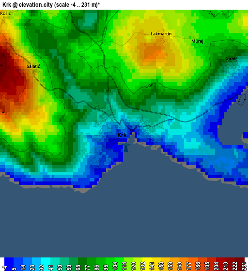
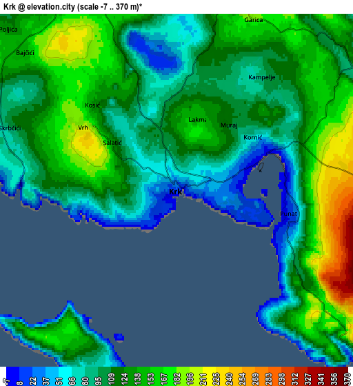
Below is the Elevation map of Krk, which displays elevation range with different colors. Scale of the first map is from -4 to 231 m (-13 to 758 ft) with average elevation of 85 meters (=279 ft) [note 1]
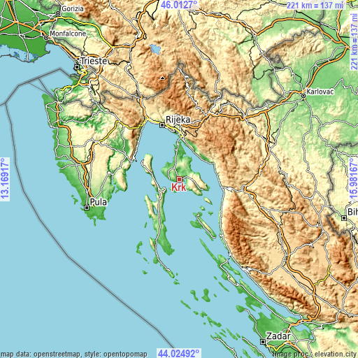
These maps also provides idea of topography and contour of this city, they are displayed at different zoom levels. More info about maps, scale and edge coordinates you can find below images.
| \ | Map #1 | Map #2 | Topo.Map |
| Scale [m] | -4..231 m | -7..370 m | × |
| Scale [ft] | -13..758 ft | -23..1214 ft | × |
| Average | 85 m = 279 ft | 119.5 m = 392 ft | × |
| Width | 6.91 km = 4.3 mi | 13.81 km = 8.6 mi | 221 km = 137.3 mi |
| Height | 6.91 km = 4.3 mi | 13.81 km = 8.6 mi | 221 km = 137.3 mi |
| ↑Max Latitude | 45.058491° | 45.089525° | 46.0127° |
| Latitude at center | 45.02744° | 45.02744° | 45.02744° |
| ↓Min Latitude | 44.996372° | 44.965288° | 44.02492° |
| ← Min Longitude | 14.531475° | 14.487529° | 13.16917° |
| Longitude center | 14.57542° | 14.57542° | 14.57542° |
| →Max Longitude | 14.619365° | 14.663311° | 15.98167° |
Nearby cities:
Cities around Krk sort by population:
• Crikvenica elevation 53 m
19 km,  28°
28°
• Novi Vinodolski 33 m
20.2 km,  56°
56°
• Cres 11 m
14.8 km,  240°
240°
• Omišalj 87 m
20.5 km,  355°
355°
• Punat 7 m
4.4 km,  108°
108°
• Bribir 146 m
21 km,  44°
44°
• Selce 12 m
18.3 km, 38°
• Jadranovo 59 m
22.9 km,  8°
8°
• Njivice 34 m
14.8 km,  348°
348°
• Vrbnik 20 m
9.3 km,  54°
54°
• Baška 10 m
15.4 km, 114°
• Dobrinj 179 m
11.2 km, 11°
Multilingual:
 En español:
Krk elevación 21 m.
 En France:
Krk élévation 21 m.


Sources and notes:
- [note 1] Map square and city borders are not equal. Map elevation data is calculated only from area inside that square.
- [src 1] Elevation data from geonames database provided with same terms of usage.
- [src 2] The elevation map of Krk is generated using elevation data from NASA's 3 arcsec (90m) resolution SRTM data.
- [src 3] Base (background) map © OpenStreetMap contributors tiles are generated by Geofabrik and OpenTopoMap.
Copyright & License:
This Krk Elevation Map is licensed under CC BY-SA. You may reuse any part from this page, if you give a proper credit by linking to this URL:
 More info on terms of use page.