Orahovica elevation
Orahovica (Virovitičk-Podravska, Grad Orahovica), Croatia elevation is 171 meters and Orahovica elevation in feet is 561 ft above sea level [src 1]. Orahovica is a seat of a second-order administrative division (feature code) with elevation that is 17 meters (56 ft) bigger than average city elevation in Croatia.
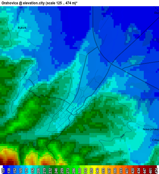
Below is the Elevation map of Orahovica, which displays elevation range with different colors. Scale of the first map is from 125 to 474 m (410 to 1555 ft) with average elevation of 190 meters (=623 ft) [note 1]
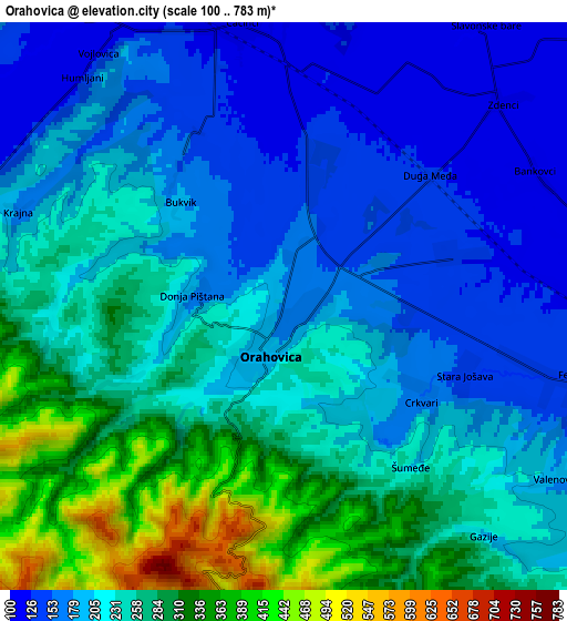
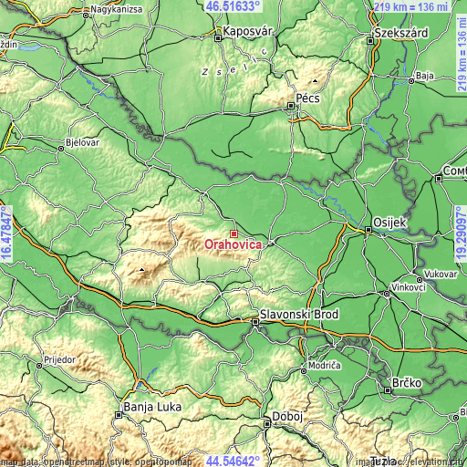
These maps also provides idea of topography and contour of this city, they are displayed at different zoom levels. More info about maps, scale and edge coordinates you can find below images.
| \ | Map #1 | Map #2 | Topo.Map |
| Scale [m] | 125..474 m | 100..783 m | × |
| Scale [ft] | 410..1555 ft | 328..2569 ft | × |
| Average | 190 m = 623 ft | 229.5 m = 753 ft | × |
| Width | 6.84 km = 4.3 mi | 13.69 km = 8.5 mi | 219 km = 136.1 mi |
| Height | 6.84 km = 4.3 mi | 13.69 km = 8.5 mi | 219 km = 136.1 mi |
| ↑Max Latitude | 45.570771° | 45.601526° | 46.51633° |
| Latitude at center | 45.54° | 45.54° | 45.54° |
| ↓Min Latitude | 45.509212° | 45.478407° | 44.54642° |
| ← Min Longitude | 17.840775° | 17.796829° | 16.47847° |
| Longitude center | 17.88472° | 17.88472° | 17.88472° |
| →Max Longitude | 17.928665° | 17.972611° | 19.29097° |
Nearby cities:
Cities around Orahovica sort by population:
• Našice elevation 153 m
16.8 km,  109°
109°
• Kutjevo 229 m
12.7 km,  180°
180°
• Čačinci 115 m
7.2 km,  351°
351°
• Feričanci 127 m
7.2 km,  99°
99°
• Kaptol 245 m
17 km,  226°
226°
• Velimirovac 104 m
17.6 km, 95°
• Martin 133 m
15.1 km, 110°
• Zdenci 109 m
7.5 km,  43°
43°
• Mikleuš 137 m
10.8 km,  324°
324°
• Ðurđenovac 112 m
12.6 km,  88°
88°
• Nova Bukovica 131 m
16.6 km,  326°
326°
• Donja Motičina 132 m
12 km, 114°
Multilingual:
 En español:
Orahovica elevación 171 m.
 En France:
Orahovica élévation 171 m.
 Auf Deutsch:
Orahovica höhe über dem Meeresspiegel ist 171 m.

Sources and notes:
- [note 1] Map square and city borders are not equal. Map elevation data is calculated only from area inside that square.
- [src 1] Elevation data from geonames database provided with same terms of usage.
- [src 2] The elevation map of Orahovica is generated using elevation data from NASA's 3 arcsec (90m) resolution SRTM data.
- [src 3] Base (background) map © OpenStreetMap contributors tiles are generated by Geofabrik and OpenTopoMap.
Copyright & License:
This Orahovica Elevation Map is licensed under CC BY-SA. You may reuse any part from this page, if you give a proper credit by linking to this URL:
 More info on terms of use page.