Plaški elevation
Plaški (Karlovačka), Croatia elevation is 377 meters and Plaški elevation in feet is 1237 ft above sea level [src 1]. Plaški is a seat of a second-order administrative division (feature code) with elevation that is 223 meters (732 ft) bigger than average city elevation in Croatia.
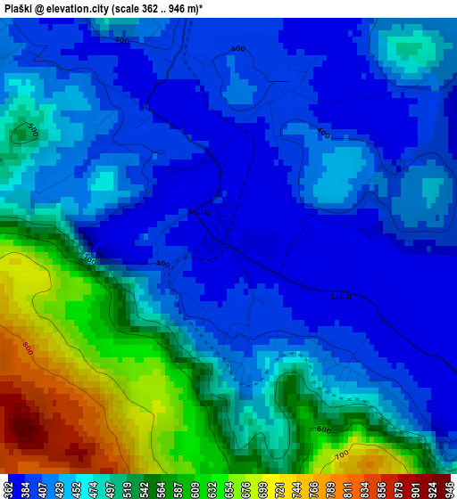
Below is the Elevation map of Plaški, which displays elevation range with different colors. Scale of the first map is from 362 to 946 m (1188 to 3104 ft) with average elevation of 475 meters (=1558 ft) [note 1]
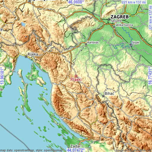
These maps also provides idea of topography and contour of this city, they are displayed at different zoom levels. More info about maps, scale and edge coordinates you can find below images.
| \ | Map #1 | Topo.Map |
| Scale [m] | 362..946 m | × |
| Scale [ft] | 1188..3104 ft | × |
| Average | 475 m = 1558 ft | × |
| Width | 6.9 km = 4.3 mi | 220.8 km = 137.2 mi |
| Height | 6.9 km = 4.3 mi | 220.8 km = 137.2 mi |
| ↑Max Latitude | 45.107414° | 46.0608° |
| Latitude at center | 45.07639° | 45.07639° |
| ↓Min Latitude | 45.045349° | 44.07472° |
| ← Min Longitude | 15.324115° | 13.96181° |
| Longitude center | 15.36806° | 15.36806° |
| →Max Longitude | 15.412005° | 16.77431° |
Nearby cities:
Cities around Plaški sort by population:
• Ogulin elevation 323 m
23.8 km,  332°
332°
• Otočac 459 m
25.2 km,  204°
204°
• Slunj 271 m
17.5 km,  75°
75°
• Brinje 477 m
20.1 km,  245°
245°
• Oštarije 314 m
18.1 km,  335°
335°
• Josipdol 343 m
13.7 km, 332°
• Cetingrad 227 m
30.6 km,  72°
72°
• Generalski Stol 200 m
30.2 km,  2°
2°
• Vrhovine 726 m
25.3 km,  170°
170°
• Rakovica 348 m
24 km,  112°
112°
• Tounj 246 m
19.7 km,  350°
350°
• Saborsko 612 m
13.5 km,  140°
140°
Multilingual:
 En español:
Plaški elevación 377 m.
 En France:
Plaški élévation 377 m.


Sources and notes:
- [note 1] Map square and city borders are not equal. Map elevation data is calculated only from area inside that square.
- [src 1] Elevation data from geonames database provided with same terms of usage.
- [src 2] The elevation map of Plaški is generated using elevation data from NASA's 3 arcsec (90m) resolution SRTM data.
- [src 3] Base (background) map © OpenStreetMap contributors tiles are generated by Geofabrik and OpenTopoMap.
Copyright & License:
This Plaški Elevation Map is licensed under CC BY-SA. You may reuse any part from this page, if you give a proper credit by linking to this URL:
 More info on terms of use page.