Zabok elevation
Zabok (Krapinsko-Zagorska, Grad Zabok), Croatia elevation is 146 meters and Zabok elevation in feet is 479 ft above sea level [src 1]. Zabok is a seat of a second-order administrative division (feature code) with elevation that is 8 meters (26 ft) smaller than average city elevation in Croatia.
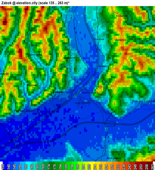
Below is the Elevation map of Zabok, which displays elevation range with different colors. Scale of the first map is from 135 to 263 m (443 to 863 ft) with average elevation of 170.2 meters (=558 ft) [note 1]
These maps also provides idea of topography and contour of this city, they are displayed at different zoom levels. More info about maps, scale and edge coordinates you can find below images.
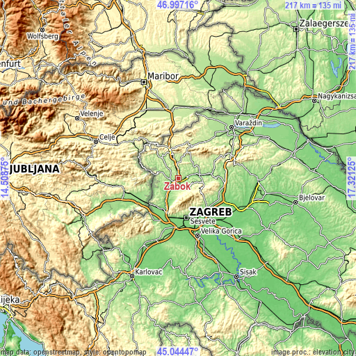
| \ | Map #1 | Topo.Map |
| Scale [m] | 135..263 m | × |
| Scale [ft] | 443..863 ft | × |
| Average | 170.2 m = 558 ft | × |
| Width | 6.78 km = 4.2 mi | 217.1 km = 134.9 mi |
| Height | 6.78 km = 4.2 mi | 217.1 km = 134.9 mi |
| ↑Max Latitude | 46.059942° | 46.99716° |
| Latitude at center | 46.02944° | 46.02944° |
| ↓Min Latitude | 45.998921° | 45.04447° |
| ← Min Longitude | 15.871055° | 14.50875° |
| Longitude center | 15.915° | 15.915° |
| →Max Longitude | 15.958945° | 17.32125° |
Nearby cities:
Cities around Zabok sort by population:
• Bedekovčina elevation 152 m
6.4 km,  78°
78°
• Oroslavje 170 m
3.6 km,  179°
179°
• Jakovlje 167 m
11.3 km,  203°
203°
• Stubičke Toplice 177 m
6.1 km,  167°
167°
• Mihovljan 227 m
12.3 km,  20°
20°
• Luka 139 m
10.8 km,  222°
222°
• Mače 163 m
11.8 km,  51°
51°
• Gornja Stubica 207 m
10.1 km,  126°
126°
• Krapinske Toplice 251 m
9 km,  322°
322°
• Donja Stubica 177 m
6.5 km,  142°
142°
• Veliko Trgovišće 138 m
6 km,  236°
236°
• Sveti Križ Začretje 152 m
5.7 km,  356°
356°
Multilingual:
 En español:
Zabok elevación 146 m.
 En France:
Zabok élévation 146 m.


Sources and notes:
- [note 1] Map square and city borders are not equal. Map elevation data is calculated only from area inside that square.
- [src 1] Elevation data from geonames database provided with same terms of usage.
- [src 2] The elevation map of Zabok is generated using elevation data from NASA's 3 arcsec (90m) resolution SRTM data.
- [src 3] Base (background) map © OpenStreetMap contributors tiles are generated by Geofabrik and OpenTopoMap.
Copyright & License:
This Zabok Elevation Map is licensed under CC BY-SA. You may reuse any part from this page, if you give a proper credit by linking to this URL:
 More info on terms of use page.