Jakovlje elevation
Jakovlje (Zagrebačka), Croatia elevation is 167 meters and Jakovlje elevation in feet is 548 ft above sea level [src 1]. Jakovlje is a seat of a second-order administrative division (feature code) with elevation that is 13 meters (43 ft) bigger than average city elevation in Croatia.
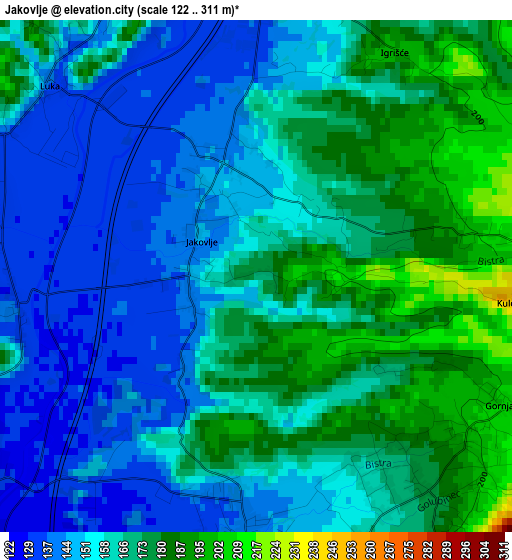
Below is the Elevation map of Jakovlje, which displays elevation range with different colors. Scale of the first map is from 122 to 311 m (400 to 1020 ft) with average elevation of 161.8 meters (=531 ft) [note 1]
These maps also provides idea of topography and contour of this city, they are displayed at different zoom levels. More info about maps, scale and edge coordinates you can find below images.
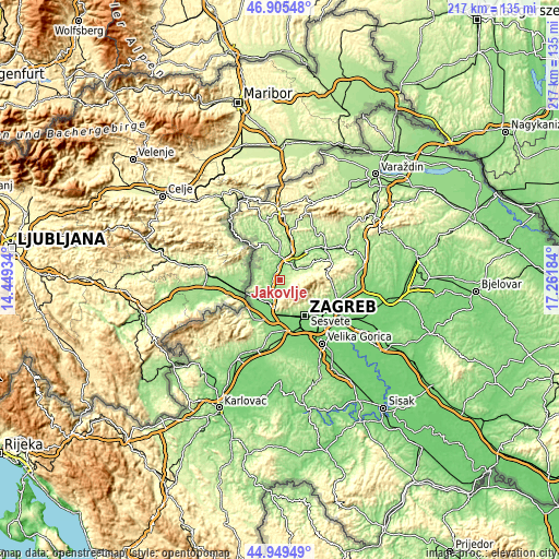
| \ | Map #1 | Topo.Map |
| Scale [m] | 122..311 m | × |
| Scale [ft] | 400..1020 ft | × |
| Average | 161.8 m = 531 ft | × |
| Width | 6.8 km = 4.2 mi | 217.5 km = 135.1 mi |
| Height | 6.8 km = 4.2 mi | 217.5 km = 135.1 mi |
| ↑Max Latitude | 45.966664° | 46.90548° |
| Latitude at center | 45.93611° | 45.93611° |
| ↓Min Latitude | 45.905539° | 44.94949° |
| ← Min Longitude | 15.811645° | 14.44934° |
| Longitude center | 15.85559° | 15.85559° |
| →Max Longitude | 15.899535° | 17.26184° |
Nearby cities:
Cities around Jakovlje sort by population:
• Zaprešić elevation 129 m
9.6 km,  202°
202°
• Oroslavje 170 m
8.2 km,  34°
34°
• Stubičke Toplice 177 m
7.4 km,  53°
53°
• Gornja Bistra 214 m
4.1 km,  122°
122°
• Donja Bistra 141 m
3.2 km,  181°
181°
• Jablanovec 192 m
6.7 km, 181°
• Pojatno 156 m
5.5 km,  230°
230°
• Luka 139 m
3.7 km,  311°
311°
• Dubravica 156 m
9.6 km,  279°
279°
• Veliko Trgovišće 138 m
7.1 km,  356°
356°
• Donja Pušća 165 m
6.4 km,  250°
250°
• Poljanica Bistranska 173 m
4.2 km,  158°
158°
Multilingual:
 En español:
Jakovlje elevación 167 m.
 En France:
Jakovlje élévation 167 m.
 Auf Deutsch:
Jakovlje höhe über dem Meeresspiegel ist 167 m.

Sources and notes:
- [note 1] Map square and city borders are not equal. Map elevation data is calculated only from area inside that square.
- [src 1] Elevation data from geonames database provided with same terms of usage.
- [src 2] The elevation map of Jakovlje is generated using elevation data from NASA's 3 arcsec (90m) resolution SRTM data.
- [src 3] Base (background) map © OpenStreetMap contributors tiles are generated by Geofabrik and OpenTopoMap.
Copyright & License:
This Jakovlje Elevation Map is licensed under CC BY-SA. You may reuse any part from this page, if you give a proper credit by linking to this URL:
 More info on terms of use page.