Azacualpa elevation
Azacualpa (Santa Bárbara), Honduras elevation is 278 meters and Azacualpa elevation in feet is 912 ft above sea level [src 1]. Azacualpa is a populated place (feature code) with elevation that is 265 meters (869 ft) smaller than average city elevation in Honduras.
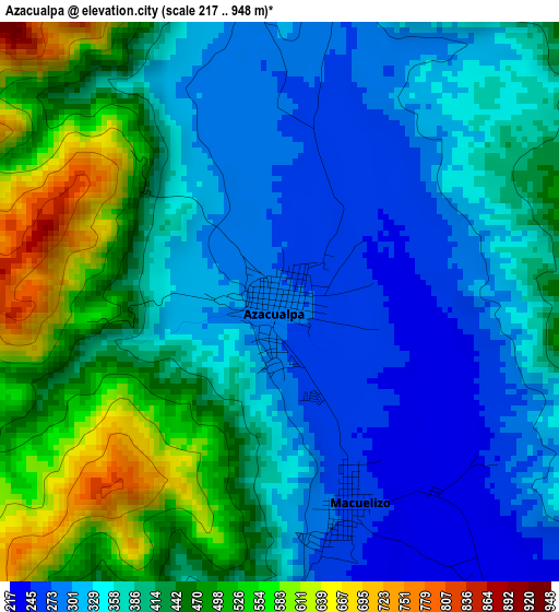
Below is the Elevation map of Azacualpa, which displays elevation range with different colors. Scale of the first map is from 217 to 948 m (712 to 3110 ft) with average elevation of 392 meters (=1286 ft) [note 1]
These maps also provides idea of topography and contour of this city, they are displayed at different zoom levels. More info about maps, scale and edge coordinates you can find below images.
| \ | Map #1 | Map #2 | Topo.Map |
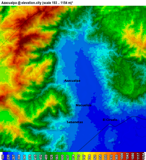
| Scale [m] | 217..948 m | 193..1154 m | × |
| Scale [ft] | 712..3110 ft | 633..3786 ft | × |
| Average | 392 m = 1286 ft | 520.3 m = 1707 ft | × |
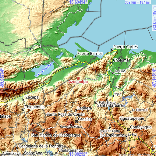
| Width | 9.42 km = 5.9 mi | 18.85 km = 11.7 mi | 301.5 km = 187.3 mi |
| Height | 9.42 km = 5.9 mi | 18.85 km = 11.7 mi | 301.6 km = 187.4 mi |
| ↑Max Latitude | 15.385705° | 15.428071° | 16.69494° |
| Latitude at center | 15.34333° | 15.34333° | 15.34333° |
| ↓Min Latitude | 15.300947° | 15.258555° | 13.98292° |
| ← Min Longitude | -88.595335° | -88.639281° | -89.95764° |
| Longitude center | -88.55139° | -88.55139° | -88.55139° |
| →Max Longitude | -88.507445° | -88.463499° | -87.14514° |
Nearby cities:
Cities around Azacualpa sort by population:
• Tras Cerros elevation 625 m
13.3 km,  248°
248°
• San Marcos 229 m
15.2 km,  108°
108°
• Quimistán 198 m
16.2 km,  87°
87°
• El Ciruelo 245 m
7.3 km,  131°
131°
• Sula 302 m
10.5 km,  188°
188°
• La Flecha 201 m
9.9 km, 132°
• Agualote 286 m
0.9 km, 191°
• San José de Tarros 729 m
16.6 km, 253°
• Joconal 692 m
9.1 km,  277°
277°
• Correderos 600 m
13.6 km,  53°
53°
• Loma Alta 461 m
6 km,  351°
351°
• Casa Quemada 259 m
8.5 km,  178°
178°
Multilingual:
 En español:
Azacualpa elevación 278 m.
 En France:
Azacualpa élévation 278 m.
 Auf Deutsch:
Azacualpa höhe über dem Meeresspiegel ist 278 m.

Sources and notes:
- [note 1] Map square and city borders are not equal. Map elevation data is calculated only from area inside that square.
- [src 1] Elevation data from geonames database provided with same terms of usage.
- [src 2] The elevation map of Azacualpa is generated using elevation data from NASA's 3 arcsec (90m) resolution SRTM data.
- [src 3] Base (background) map © OpenStreetMap contributors tiles are generated by Geofabrik and OpenTopoMap.
Copyright & License:
This Azacualpa Elevation Map is licensed under CC BY-SA. You may reuse any part from this page, if you give a proper credit by linking to this URL:
 More info on terms of use page.