San Marcos elevation
San Marcos (Santa Bárbara), Honduras elevation is 229 meters and San Marcos elevation in feet is 751 ft above sea level [src 1]. San Marcos is a populated place (feature code) with elevation that is 314 meters (1030 ft) smaller than average city elevation in Honduras.
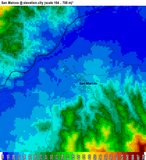
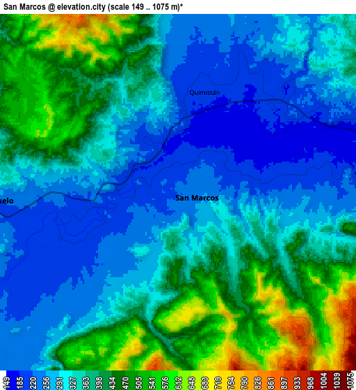
Below is the Elevation map of San Marcos, which displays elevation range with different colors. Scale of the first map is from 164 to 708 m (538 to 2323 ft) with average elevation of 261.3 meters (=857 ft) [note 1]
These maps also provides idea of topography and contour of this city, they are displayed at different zoom levels. More info about maps, scale and edge coordinates you can find below images.
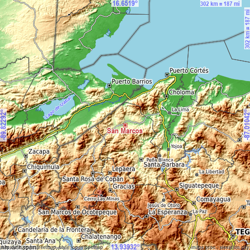
| \ | Map #1 | Map #2 | Topo.Map |
| Scale [m] | 164..708 m | 149..1075 m | × |
| Scale [ft] | 538..2323 ft | 489..3527 ft | × |
| Average | 261.3 m = 857 ft | 360.3 m = 1182 ft | × |
| Width | 9.43 km = 5.9 mi | 18.85 km = 11.7 mi | 301.6 km = 187.4 mi |
| Height | 9.43 km = 5.9 mi | 18.85 km = 11.7 mi | 301.6 km = 187.4 mi |
| ↑Max Latitude | 15.342383° | 15.384758° | 16.6519° |
| Latitude at center | 15.3° | 15.3° | 15.3° |
| ↓Min Latitude | 15.257608° | 15.215207° | 13.93932° |
| ← Min Longitude | -88.460615° | -88.504561° | -89.82292° |
| Longitude center | -88.41667° | -88.41667° | -88.41667° |
| →Max Longitude | -88.372725° | -88.328779° | -87.01042° |
Nearby cities:
Cities around San Marcos sort by population:
• Azacualpa elevation 278 m
15.2 km,  288°
288°
• Pinalejo 239 m
9.4 km,  10°
10°
• Quimistán 198 m
5.8 km,  17°
17°
• El Ciruelo 245 m
8.9 km,  270°
270°
• Sula 302 m
17 km,  250°
250°
• La Flecha 201 m
7.4 km,  255°
255°
• Agualote 286 m
15.1 km, 285°
• Camalote 201 m
9.7 km,  67°
67°
• Correderos 600 m
13.5 km,  344°
344°
• Loma Alta 461 m
18.7 km,  305°
305°
• Petoa 270 m
14.8 km,  104°
104°
• Casa Quemada 259 m
14.8 km, 255°
Multilingual:
 En español:
San Marcos elevación 229 m.
 En France:
San Marcos élévation 229 m.
 Auf Deutsch:
San Marcos höhe über dem Meeresspiegel ist 229 m.

Sources and notes:
- [note 1] Map square and city borders are not equal. Map elevation data is calculated only from area inside that square.
- [src 1] Elevation data from geonames database provided with same terms of usage.
- [src 2] The elevation map of San Marcos is generated using elevation data from NASA's 3 arcsec (90m) resolution SRTM data.
- [src 3] Base (background) map © OpenStreetMap contributors tiles are generated by Geofabrik and OpenTopoMap.
Copyright & License:
This San Marcos Elevation Map is licensed under CC BY-SA. You may reuse any part from this page, if you give a proper credit by linking to this URL:
 More info on terms of use page.