El Llano elevation
El Llano (Cortés), Honduras elevation is 53 meters and El Llano elevation in feet is 174 ft above sea level [src 1]. El Llano is a populated place (feature code) with elevation that is 490 meters (1608 ft) smaller than average city elevation in Honduras.
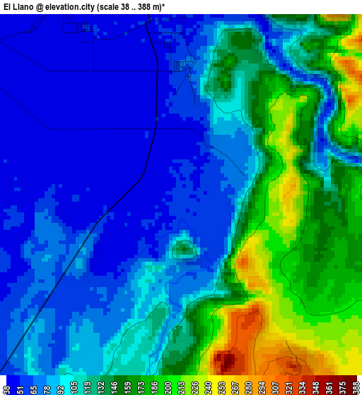
Below is the Elevation map of El Llano, which displays elevation range with different colors. Scale of the first map is from 38 to 388 m (125 to 1273 ft) with average elevation of 111 meters (=364 ft) [note 1]
These maps also provides idea of topography and contour of this city, they are displayed at different zoom levels. More info about maps, scale and edge coordinates you can find below images.
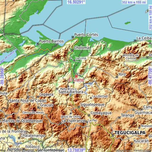
| \ | Map #1 | Topo.Map |
| Scale [m] | 38..388 m | × |
| Scale [ft] | 125..1273 ft | × |
| Average | 111 m = 364 ft | × |
| Width | 9.43 km = 5.9 mi | 301.8 km = 187.5 mi |
| Height | 9.43 km = 5.9 mi | 301.8 km = 187.5 mi |
| ↑Max Latitude | 15.192414° | 16.50291° |
| Latitude at center | 15.15° | 15.15° |
| ↓Min Latitude | 15.107578° | 13.78839° |
| ← Min Longitude | -87.927275° | -89.28958° |
| Longitude center | -87.88333° | -87.88333° |
| →Max Longitude | -87.839385° | -86.47708° |
Nearby cities:
Cities around El Llano sort by population:
• Potrerillos elevation 92 m
12.9 km,  316°
316°
• Pimienta Vieja 92 m
12.9 km, 316°
• Agua Blanca Sur 49 m
11.1 km,  0°
0°
• San Antonio de Cortés 582 m
16.5 km,  257°
257°
• Río Lindo 145 m
16.8 km,  219°
219°
• La Guacamaya 1356 m
14.3 km,  38°
38°
• La Sarrosa 666 m
10.7 km,  30°
30°
• El Plan 66 m
17.3 km,  328°
328°
• San Francisco de Yojoa 262 m
17.3 km,  211°
211°
• Oropéndolas 165 m
15.8 km,  199°
199°
• El Olivar 244 m
7.4 km,  180°
180°
• Bejuco 47 m
5.7 km,  250°
250°
Multilingual:
 En español:
El Llano elevación 53 m.
 En France:
El Llano élévation 53 m.


Sources and notes:
- [note 1] Map square and city borders are not equal. Map elevation data is calculated only from area inside that square.
- [src 1] Elevation data from geonames database provided with same terms of usage.
- [src 2] The elevation map of El Llano is generated using elevation data from NASA's 3 arcsec (90m) resolution SRTM data.
- [src 3] Base (background) map © OpenStreetMap contributors tiles are generated by Geofabrik and OpenTopoMap.
Copyright & License:
This El Llano Elevation Map is licensed under CC BY-SA. You may reuse any part from this page, if you give a proper credit by linking to this URL:
 More info on terms of use page.