San Antonio de Cortés elevation
San Antonio de Cortés (Cortés), Honduras elevation is 582 meters and San Antonio de Cortés elevation in feet is 1909 ft above sea level [src 1]. San Antonio de Cortés is a populated place (feature code) with elevation that is 39 meters (128 ft) bigger than average city elevation in Honduras.
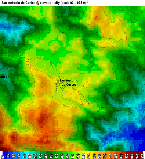
Below is the Elevation map of San Antonio de Cortés, which displays elevation range with different colors. Scale of the first map is from 93 to 975 m (305 to 3199 ft) with average elevation of 501.8 meters (=1646 ft) [note 1]
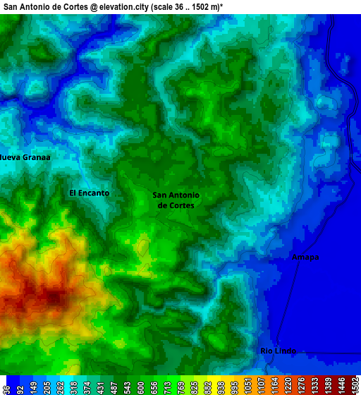
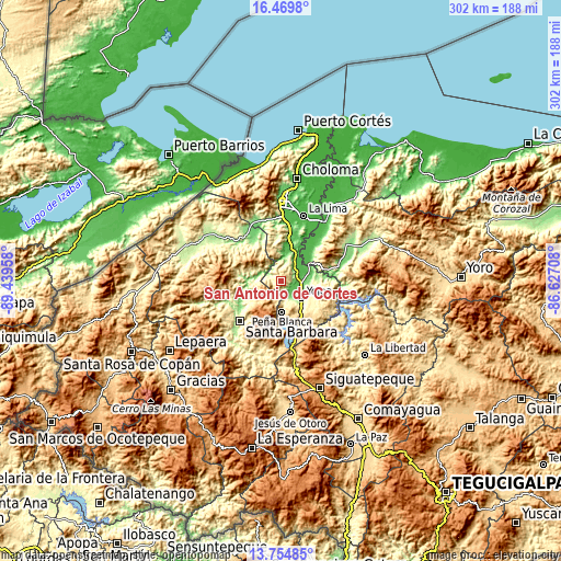
These maps also provides idea of topography and contour of this city, they are displayed at different zoom levels. More info about maps, scale and edge coordinates you can find below images.
| \ | Map #1 | Map #2 | Topo.Map |
| Scale [m] | 93..975 m | 36..1502 m | × |
| Scale [ft] | 305..3199 ft | 118..4928 ft | × |
| Average | 501.8 m = 1646 ft | 421.7 m = 1384 ft | × |
| Width | 9.43 km = 5.9 mi | 18.87 km = 11.7 mi | 301.9 km = 187.6 mi |
| Height | 9.43 km = 5.9 mi | 18.87 km = 11.7 mi | 301.9 km = 187.6 mi |
| ↑Max Latitude | 15.15909° | 15.201502° | 16.4698° |
| Latitude at center | 15.11667° | 15.11667° | 15.11667° |
| ↓Min Latitude | 15.074241° | 15.031804° | 13.75485° |
| ← Min Longitude | -88.077275° | -88.121221° | -89.43958° |
| Longitude center | -88.03333° | -88.03333° | -88.03333° |
| →Max Longitude | -87.989385° | -87.945439° | -86.62708° |
Nearby cities:
Cities around San Antonio de Cortés sort by population:
• Potrerillos elevation 92 m
14.8 km,  28°
28°
• Pimienta Vieja 92 m
14.8 km, 28°
• Río Lindo 145 m
10.7 km,  149°
149°
• Casa Quemada 389 m
5.4 km,  270°
270°
• Cañaveral 506 m
14.9 km,  173°
173°
• San Francisco de Yojoa 262 m
13.2 km, 147°
• El Llano 53 m
16.5 km,  77°
77°
• San Buenaventura 414 m
11.7 km,  162°
162°
• Oropéndolas 165 m
15.5 km,  136°
136°
• El Olivar 244 m
16.5 km,  102°
102°
• Bejuco 47 m
10.9 km, 80°
• El Perico 900 m
8.1 km,  242°
242°
Multilingual:
 En español:
San Antonio de Cortés elevación 582 m.
 En France:
San Antonio de Cortés élévation 582 m.
 Auf Deutsch:
San Antonio de Cortés höhe über dem Meeresspiegel ist 582 m.
 На русском:
San Antonio de Cortés высота над уровнем моря 582 м
Sources and notes:
- [note 1] Map square and city borders are not equal. Map elevation data is calculated only from area inside that square.
- [src 1] Elevation data from geonames database provided with same terms of usage.
- [src 2] The elevation map of San Antonio de Cortés is generated using elevation data from NASA's 3 arcsec (90m) resolution SRTM data.
- [src 3] Base (background) map © OpenStreetMap contributors tiles are generated by Geofabrik and OpenTopoMap.
Copyright & License:
This San Antonio de Cortés Elevation Map is licensed under CC BY-SA. You may reuse any part from this page, if you give a proper credit by linking to this URL:
 More info on terms of use page.