Marcala elevation
Marcala (La Paz), Honduras elevation is 1248 meters and Marcala elevation in feet is 4094 ft above sea level [src 1]. Marcala is a populated place (feature code) with elevation that is 705 meters (2313 ft) bigger than average city elevation in Honduras.
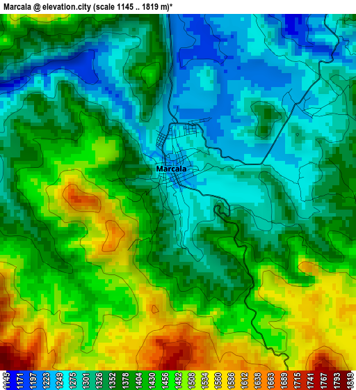
Below is the Elevation map of Marcala, which displays elevation range with different colors. Scale of the first map is from 1145 to 1819 m (3757 to 5968 ft) with average elevation of 1386 meters (=4547 ft) [note 1]
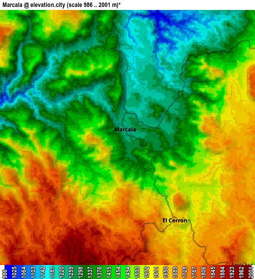
These maps also provides idea of topography and contour of this city, they are displayed at different zoom levels. More info about maps, scale and edge coordinates you can find below images.
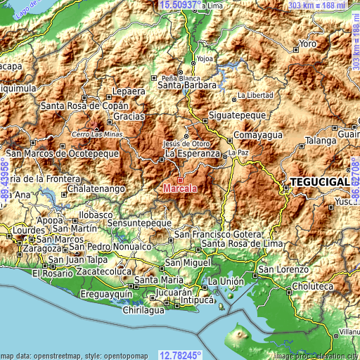
| \ | Map #1 | Map #2 | Topo.Map |
| Scale [m] | 1145..1819 m | 986..2001 m | × |
| Scale [ft] | 3757..5968 ft | 3235..6565 ft | × |
| Average | 1386 m = 4547 ft | 1497.9 m = 4914 ft | × |
| Width | 9.48 km = 5.9 mi | 18.95 km = 11.8 mi | 303.2 km = 188.4 mi |
| Height | 9.48 km = 5.9 mi | 18.95 km = 11.8 mi | 303.2 km = 188.4 mi |
| ↑Max Latitude | 14.192608° | 14.235208° | 15.50937° |
| Latitude at center | 14.15° | 14.15° | 14.15° |
| ↓Min Latitude | 14.107384° | 14.06476° | 12.78245° |
| ← Min Longitude | -88.077275° | -88.121221° | -89.43958° |
| Longitude center | -88.03333° | -88.03333° | -88.03333° |
| →Max Longitude | -87.989385° | -87.945439° | -86.62708° |
Nearby cities:
Cities around Marcala sort by population:
• Intibucá elevation 1692 m
23.5 km,  322°
322°
• Jesús de Otoro 612 m
37.5 km,  8°
8°
• La Esperanza 1697 m
23.9 km, 318°
• Santiago Puringla 1036 m
26.5 km,  32°
32°
• Cane 659 m
42.2 km,  69°
69°
• San Pedro de Tutule 1257 m
22.7 km,  60°
60°
• San José 1333 m
14.3 km,  38°
38°
• Los Planes 1811 m
11.3 km,  170°
170°
• Jiquinlaca 552 m
38 km,  243°
243°
• Yamaranguila 1737 m
27.7 km,  302°
302°
• Camasca 800 m
41.3 km,  246°
246°
• Tepanguare 1672 m
36.7 km, 56°
Multilingual:
 En español:
Marcala elevación 1248 m.
 En France:
Marcala élévation 1248 m.
 Auf Deutsch:
Marcala höhe über dem Meeresspiegel ist 1248 m.

Sources and notes:
- [note 1] Map square and city borders are not equal. Map elevation data is calculated only from area inside that square.
- [src 1] Elevation data from geonames database provided with same terms of usage.
- [src 2] The elevation map of Marcala is generated using elevation data from NASA's 3 arcsec (90m) resolution SRTM data.
- [src 3] Base (background) map © OpenStreetMap contributors tiles are generated by Geofabrik and OpenTopoMap.
Copyright & License:
This Marcala Elevation Map is licensed under CC BY-SA. You may reuse any part from this page, if you give a proper credit by linking to this URL:
 More info on terms of use page.