Morazán elevation
Morazán (Yoro), Honduras elevation is 211 meters and Morazán elevation in feet is 692 ft above sea level [src 1]. Morazán is a populated place (feature code) with elevation that is 332 meters (1089 ft) smaller than average city elevation in Honduras.
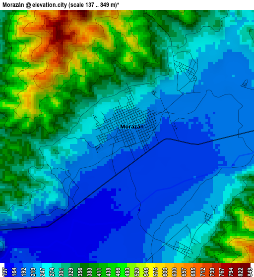
Below is the Elevation map of Morazán, which displays elevation range with different colors. Scale of the first map is from 137 to 849 m (449 to 2785 ft) with average elevation of 302.2 meters (=991 ft) [note 1]
These maps also provides idea of topography and contour of this city, they are displayed at different zoom levels. More info about maps, scale and edge coordinates you can find below images.
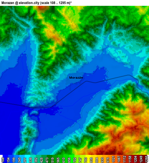
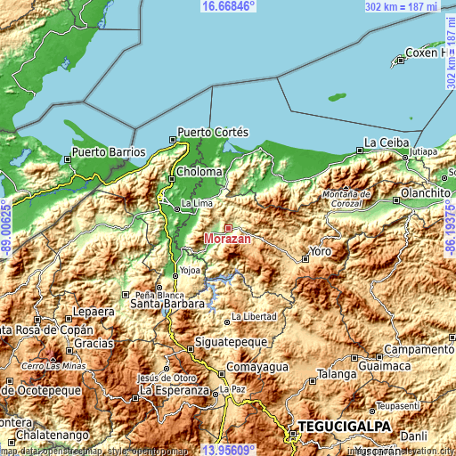
| \ | Map #1 | Map #2 | Topo.Map |
| Scale [m] | 137..849 m | 108..1295 m | × |
| Scale [ft] | 449..2785 ft | 354..4249 ft | × |
| Average | 302.2 m = 991 ft | 424.8 m = 1394 ft | × |
| Width | 9.43 km = 5.9 mi | 18.85 km = 11.7 mi | 301.6 km = 187.4 mi |
| Height | 9.43 km = 5.9 mi | 18.85 km = 11.7 mi | 301.6 km = 187.4 mi |
| ↑Max Latitude | 15.35905° | 15.401422° | 16.66846° |
| Latitude at center | 15.31667° | 15.31667° | 15.31667° |
| ↓Min Latitude | 15.274281° | 15.231884° | 13.95609° |
| ← Min Longitude | -87.643945° | -87.687891° | -89.00625° |
| Longitude center | -87.6° | -87.6° | -87.6° |
| →Max Longitude | -87.556055° | -87.512109° | -86.19375° |
Nearby cities:
Cities around Morazán sort by population:
• El Progreso elevation 48 m
23.4 km,  293°
293°
• El Negrito 231 m
10.7 km,  270°
270°
• La Mina 69 m
25 km, 270°
• Toyós 61 m
26.5 km,  348°
348°
• La Guacamaya 1356 m
22.7 km,  250°
250°
• Guaimitas 47 m
23.9 km,  328°
328°
• La Sarrosa 666 m
26.7 km, 249°
• Nueva Esperanza 206 m
5.6 km,  180°
180°
• Ocote Paulino 683 m
11.1 km,  0°
0°
• La Estancia 778 m
6.5 km,  124°
124°
• Mojimán 206 m
5.6 km, 180°
• Subirana 837 m
20.7 km,  128°
128°
Multilingual:
 En español:
Morazán elevación 211 m.
 En France:
Morazán élévation 211 m.


Sources and notes:
- [note 1] Map square and city borders are not equal. Map elevation data is calculated only from area inside that square.
- [src 1] Elevation data from geonames database provided with same terms of usage.
- [src 2] The elevation map of Morazán is generated using elevation data from NASA's 3 arcsec (90m) resolution SRTM data.
- [src 3] Base (background) map © OpenStreetMap contributors tiles are generated by Geofabrik and OpenTopoMap.
Copyright & License:
This Morazán Elevation Map is licensed under CC BY-SA. You may reuse any part from this page, if you give a proper credit by linking to this URL:
 More info on terms of use page.