El Progreso elevation
El Progreso (Yoro), Honduras elevation is 48 meters and El Progreso elevation in feet is 157 ft above sea level [src 1]. El Progreso is a populated place (feature code) with elevation that is 495 meters (1624 ft) smaller than average city elevation in Honduras.
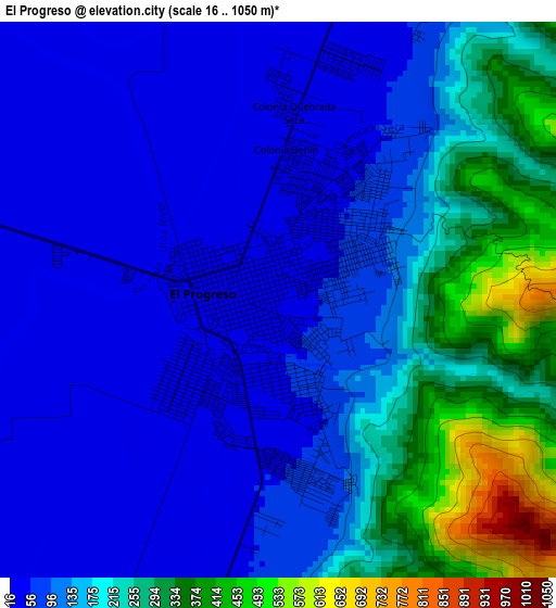
Below is the Elevation map of El Progreso, which displays elevation range with different colors. Scale of the first map is from 16 to 1050 m (52 to 3445 ft) with average elevation of 150 meters (=492 ft) [note 1]
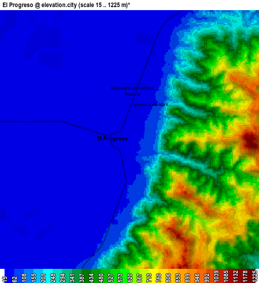
These maps also provides idea of topography and contour of this city, they are displayed at different zoom levels. More info about maps, scale and edge coordinates you can find below images.
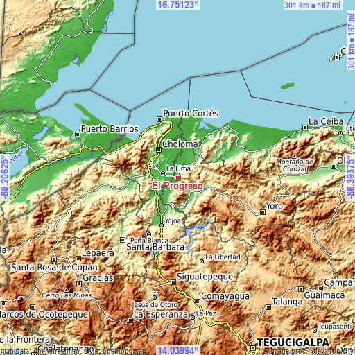
| \ | Map #1 | Map #2 | Topo.Map |
| Scale [m] | 16..1050 m | 15..1225 m | × |
| Scale [ft] | 52..3445 ft | 49..4019 ft | × |
| Average | 150 m = 492 ft | 250.3 m = 821 ft | × |
| Width | 9.42 km = 5.9 mi | 18.84 km = 11.7 mi | 301.5 km = 187.3 mi |
| Height | 9.42 km = 5.9 mi | 18.84 km = 11.7 mi | 301.5 km = 187.3 mi |
| ↑Max Latitude | 15.442363° | 15.484718° | 16.75123° |
| Latitude at center | 15.4° | 15.4° | 15.4° |
| ↓Min Latitude | 15.357628° | 15.315248° | 14.03994° |
| ← Min Longitude | -87.843945° | -87.887891° | -89.20625° |
| Longitude center | -87.8° | -87.8° | -87.8° |
| →Max Longitude | -87.756055° | -87.712109° | -86.39375° |
Nearby cities:
Cities around El Progreso sort by population:
• La Lima elevation 33 m
13 km,  286°
286°
• El Negrito 231 m
14.2 km,  130°
130°
• Agua Blanca Sur 49 m
18.9 km,  208°
208°
• San Manuel 44 m
14.5 km,  239°
239°
• Victoria 23 m
11.9 km,  346°
346°
• La Mina 69 m
9.9 km,  201°
201°
• La Guacamaya 1356 m
16.7 km,  180°
180°
• Guaimitas 47 m
14.3 km,  38°
38°
• La Sarrosa 666 m
18.9 km,  190°
190°
• El Milagro 38 m
17.9 km,  270°
270°
• La Sabana 100 m
14.8 km,  255°
255°
• San José del Boquerón 22 m
11.7 km,  322°
322°
Multilingual:
 En español:
El Progreso elevación 48 m.
 En France:
El Progreso élévation 48 m.
 Auf Deutsch:
El Progreso höhe über dem Meeresspiegel ist 48 m.

Sources and notes:
- [note 1] Map square and city borders are not equal. Map elevation data is calculated only from area inside that square.
- [src 1] Elevation data from geonames database provided with same terms of usage.
- [src 2] The elevation map of El Progreso is generated using elevation data from NASA's 3 arcsec (90m) resolution SRTM data.
- [src 3] Base (background) map © OpenStreetMap contributors tiles are generated by Geofabrik and OpenTopoMap.
Copyright & License:
This El Progreso Elevation Map is licensed under CC BY-SA. You may reuse any part from this page, if you give a proper credit by linking to this URL:
 More info on terms of use page.