Reitoca elevation
Reitoca (Francisco Morazán), Honduras elevation is 304 meters and Reitoca elevation in feet is 997 ft above sea level [src 1]. Reitoca is a populated place (feature code) with elevation that is 239 meters (784 ft) smaller than average city elevation in Honduras.
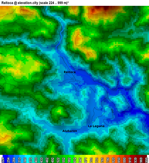
Below is the Elevation map of Reitoca, which displays elevation range with different colors. Scale of the first map is from 224 to 999 m (735 to 3278 ft) with average elevation of 462.5 meters (=1517 ft) [note 1]
These maps also provides idea of topography and contour of this city, they are displayed at different zoom levels. More info about maps, scale and edge coordinates you can find below images.
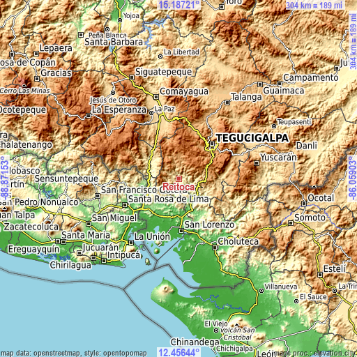
| \ | Map #1 | Topo.Map |
| Scale [m] | 224..999 m | × |
| Scale [ft] | 735..3278 ft | × |
| Average | 462.5 m = 1517 ft | × |
| Width | 9.49 km = 5.9 mi | 303.6 km = 188.6 mi |
| Height | 9.49 km = 5.9 mi | 303.7 km = 188.7 mi |
| ↑Max Latitude | 13.868498° | 15.18721° |
| Latitude at center | 13.82583° | 13.82583° |
| ↓Min Latitude | 13.783154° | 12.45644° |
| ← Min Longitude | -87.509225° | -88.87153° |
| Longitude center | -87.46528° | -87.46528° |
| →Max Longitude | -87.421335° | -86.05903° |
Nearby cities:
Cities around Reitoca sort by population:
• Langue elevation 151 m
30.5 km,  221°
221°
• Pespire 123 m
28.3 km,  156°
156°
• El Porvenir 556 m
14.7 km,  118°
118°
• Ojojona 1377 m
21.9 km,  56°
56°
• Lepaterique 1475 m
26.8 km,  359°
359°
• Sabanagrande 965 m
22.3 km,  95°
95°
• El Guapinol 751 m
6.6 km,  181°
181°
• San Francisco de Coray 164 m
19.7 km,  201°
201°
• Cerro Grande 1090 m
23.3 km,  92°
92°
• Aramecina 136 m
28 km,  250°
250°
• Santa Ana 1455 m
24 km, 60°
• San Antonio del Norte 301 m
26.5 km,  284°
284°
Multilingual:
 En español:
Reitoca elevación 304 m.
 En France:
Reitoca élévation 304 m.


Sources and notes:
- [note 1] Map square and city borders are not equal. Map elevation data is calculated only from area inside that square.
- [src 1] Elevation data from geonames database provided with same terms of usage.
- [src 2] The elevation map of Reitoca is generated using elevation data from NASA's 3 arcsec (90m) resolution SRTM data.
- [src 3] Base (background) map © OpenStreetMap contributors tiles are generated by Geofabrik and OpenTopoMap.
Copyright & License:
This Reitoca Elevation Map is licensed under CC BY-SA. You may reuse any part from this page, if you give a proper credit by linking to this URL:
 More info on terms of use page.