Trinidad elevation
Trinidad (Santa Bárbara), Honduras elevation is 324 meters and Trinidad elevation in feet is 1063 ft above sea level [src 1]. Trinidad is a populated place (feature code) with elevation that is 219 meters (719 ft) smaller than average city elevation in Honduras.
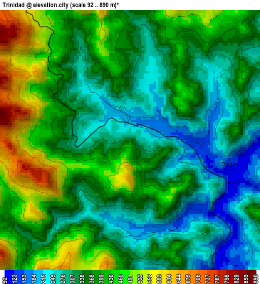
Below is the Elevation map of Trinidad, which displays elevation range with different colors. Scale of the first map is from 92 to 890 m (302 to 2920 ft) with average elevation of 365.6 meters (=1199 ft) [note 1]
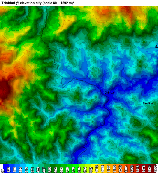
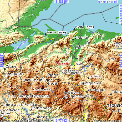
These maps also provides idea of topography and contour of this city, they are displayed at different zoom levels. More info about maps, scale and edge coordinates you can find below images.
| \ | Map #1 | Map #2 | Topo.Map |
| Scale [m] | 92..890 m | 80..1592 m | × |
| Scale [ft] | 302..2920 ft | 262..5223 ft | × |
| Average | 365.6 m = 1199 ft | 550.5 m = 1806 ft | × |
| Width | 9.43 km = 5.9 mi | 18.87 km = 11.7 mi | 301.8 km = 187.5 mi |
| Height | 9.43 km = 5.9 mi | 18.87 km = 11.7 mi | 301.9 km = 187.6 mi |
| ↑Max Latitude | 15.175747° | 15.218156° | 16.48635° |
| Latitude at center | 15.13333° | 15.13333° | 15.13333° |
| ↓Min Latitude | 15.090904° | 15.04847° | 13.77162° |
| ← Min Longitude | -88.277275° | -88.321221° | -89.63958° |
| Longitude center | -88.23333° | -88.23333° | -88.23333° |
| →Max Longitude | -88.189385° | -88.145439° | -86.82708° |
Nearby cities:
Cities around Trinidad sort by population:
• Santa Bárbara elevation 256 m
23.8 km,  180°
180°
• San Luis 1137 m
17 km,  250°
250°
• San Antonio de Cortés 582 m
21.5 km,  94°
94°
• San José de Colinas 320 m
13.2 km,  212°
212°
• Casa Quemada 389 m
16.2 km,  96°
96°
• Ilama 262 m
7.6 km,  166°
166°
• Laguna Verde 848 m
10.3 km,  43°
43°
• Gualjoco 250 m
20.4 km, 180°
• Guacamaya 673 m
15.8 km,  145°
145°
• El Perico 900 m
15.4 km,  111°
111°
• San Luis de Planes 1495 m
19.8 km, 147°
• Petoa 270 m
15.8 km,  340°
340°
Multilingual:
 En español:
Trinidad elevación 324 m.
 En France:
Trinidad élévation 324 m.
 Auf Deutsch:
Trinidad höhe über dem Meeresspiegel ist 324 m.

Sources and notes:
- [note 1] Map square and city borders are not equal. Map elevation data is calculated only from area inside that square.
- [src 1] Elevation data from geonames database provided with same terms of usage.
- [src 2] The elevation map of Trinidad is generated using elevation data from NASA's 3 arcsec (90m) resolution SRTM data.
- [src 3] Base (background) map © OpenStreetMap contributors tiles are generated by Geofabrik and OpenTopoMap.
Copyright & License:
This Trinidad Elevation Map is licensed under CC BY-SA. You may reuse any part from this page, if you give a proper credit by linking to this URL:
 More info on terms of use page.