Villa de San Antonio elevation
Villa de San Antonio (Comayagua), Honduras elevation is 596 meters and Villa de San Antonio elevation in feet is 1955 ft above sea level [src 1]. Villa de San Antonio is a populated place (feature code) with elevation that is 53 meters (174 ft) bigger than average city elevation in Honduras.
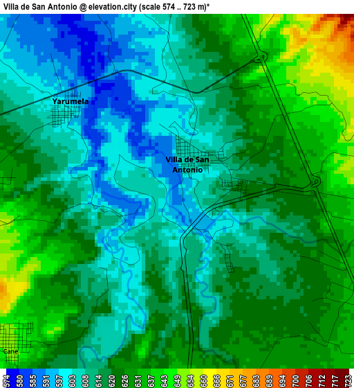
Below is the Elevation map of Villa de San Antonio, which displays elevation range with different colors. Scale of the first map is from 574 to 723 m (1883 to 2372 ft) with average elevation of 617.9 meters (=2027 ft) [note 1]
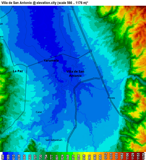
These maps also provides idea of topography and contour of this city, they are displayed at different zoom levels. More info about maps, scale and edge coordinates you can find below images.
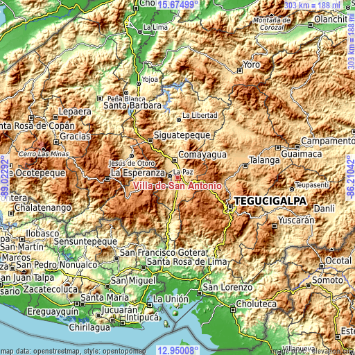
| \ | Map #1 | Map #2 | Topo.Map |
| Scale [m] | 574..723 m | 566..1176 m | × |
| Scale [ft] | 1883..2372 ft | 1857..3858 ft | × |
| Average | 617.9 m = 2027 ft | 689.8 m = 2263 ft | × |
| Width | 9.47 km = 5.9 mi | 18.94 km = 11.8 mi | 303 km = 188.3 mi |
| Height | 9.47 km = 5.9 mi | 18.94 km = 11.8 mi | 303 km = 188.3 mi |
| ↑Max Latitude | 14.359246° | 14.401815° | 15.67499° |
| Latitude at center | 14.31667° | 14.31667° | 14.31667° |
| ↓Min Latitude | 14.274085° | 14.231493° | 12.95008° |
| ← Min Longitude | -87.660615° | -87.704561° | -89.02292° |
| Longitude center | -87.61667° | -87.61667° | -87.61667° |
| →Max Longitude | -87.572725° | -87.528779° | -86.21042° |
Nearby cities:
Cities around Villa de San Antonio sort by population:
• Comayagua elevation 593 m
15.1 km,  351°
351°
• La Paz 688 m
6.7 km,  272°
272°
• Ajuterique 647 m
11.6 km,  309°
309°
• Zambrano 1358 m
24 km,  103°
103°
• Lejamaní 658 m
10.6 km,  301°
301°
• Yarumela 593 m
2.6 km,  315°
315°
• Flores 645 m
6.5 km,  124°
124°
• Cane 659 m
6.5 km,  235°
235°
• Lamaní 717 m
13 km,  180°
180°
• San Sebastián 649 m
7.6 km,  193°
193°
• Valle de Ángeles 687 m
20.5 km, 354°
• Tepanguare 1672 m
14.5 km,  277°
277°
Multilingual:
 En español:
Villa de San Antonio elevación 596 m.
 En France:
Villa de San Antonio élévation 596 m.
 Auf Deutsch:
Villa de San Antonio höhe über dem Meeresspiegel ist 596 m.
 На русском:
Villa de San Antonio высота над уровнем моря 596 м
Sources and notes:
- [note 1] Map square and city borders are not equal. Map elevation data is calculated only from area inside that square.
- [src 1] Elevation data from geonames database provided with same terms of usage.
- [src 2] The elevation map of Villa de San Antonio is generated using elevation data from NASA's 3 arcsec (90m) resolution SRTM data.
- [src 3] Base (background) map © OpenStreetMap contributors tiles are generated by Geofabrik and OpenTopoMap.
Copyright & License:
This Villa de San Antonio Elevation Map is licensed under CC BY-SA. You may reuse any part from this page, if you give a proper credit by linking to this URL:
 More info on terms of use page.