Zambrano elevation
Zambrano (Francisco Morazán), Honduras elevation is 1358 meters and Zambrano elevation in feet is 4455 ft above sea level [src 1]. Zambrano is a populated place (feature code) with elevation that is 815 meters (2674 ft) bigger than average city elevation in Honduras.
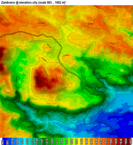
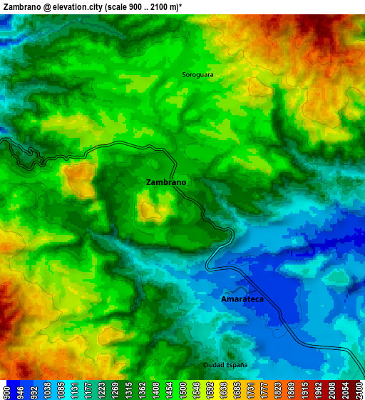
Below is the Elevation map of Zambrano, which displays elevation range with different colors. Scale of the first map is from 963 to 1692 m (3159 to 5551 ft) with average elevation of 1334.8 meters (=4379 ft) [note 1]
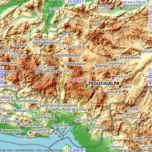
These maps also provides idea of topography and contour of this city, they are displayed at different zoom levels. More info about maps, scale and edge coordinates you can find below images.
| \ | Map #1 | Map #2 | Topo.Map |
| Scale [m] | 963..1692 m | 900..2100 m | × |
| Scale [ft] | 3159..5551 ft | 2953..6890 ft | × |
| Average | 1334.8 m = 4379 ft | 1371 m = 4498 ft | × |
| Width | 9.47 km = 5.9 mi | 18.94 km = 11.8 mi | 303 km = 188.3 mi |
| Height | 9.47 km = 5.9 mi | 18.94 km = 11.8 mi | 303.1 km = 188.3 mi |
| ↑Max Latitude | 14.309256° | 14.351834° | 15.62531° |
| Latitude at center | 14.26667° | 14.26667° | 14.26667° |
| ↓Min Latitude | 14.224076° | 14.181474° | 12.89979° |
| ← Min Longitude | -87.443945° | -87.487891° | -88.80625° |
| Longitude center | -87.4° | -87.4° | -87.4° |
| →Max Longitude | -87.356055° | -87.312109° | -85.99375° |
Nearby cities:
Cities around Zambrano sort by population:
• Villa de San Antonio elevation 596 m
24 km,  283°
283°
• Yarumela 593 m
26.2 km,  286°
286°
• Flores 645 m
18.1 km, 275°
• Támara 1304 m
14.8 km,  151°
151°
• Lepaterique 1475 m
23.4 km,  197°
197°
• Río Abajo 1027 m
22.7 km,  119°
119°
• Lamaní 717 m
24.5 km,  252°
252°
• San Sebastián 649 m
25.2 km,  265°
265°
• El Lolo 1551 m
22 km,  139°
139°
• Cofradía 1131 m
24 km,  103°
103°
• Agalteca 724 m
24.9 km,  35°
35°
• Mateo 1127 m
22.3 km,  156°
156°
Multilingual:
 En español:
Zambrano elevación 1358 m.
 En France:
Zambrano élévation 1358 m.
 Auf Deutsch:
Zambrano höhe über dem Meeresspiegel ist 1358 m.

Sources and notes:
- [note 1] Map square and city borders are not equal. Map elevation data is calculated only from area inside that square.
- [src 1] Elevation data from geonames database provided with same terms of usage.
- [src 2] The elevation map of Zambrano is generated using elevation data from NASA's 3 arcsec (90m) resolution SRTM data.
- [src 3] Base (background) map © OpenStreetMap contributors tiles are generated by Geofabrik and OpenTopoMap.
Copyright & License:
This Zambrano Elevation Map is licensed under CC BY-SA. You may reuse any part from this page, if you give a proper credit by linking to this URL:
 More info on terms of use page.