Cahabón elevation
Cahabón (Alta Verapaz), Guatemala elevation is 522 meters and Cahabón elevation in feet is 1713 ft above sea level [src 1]. Cahabón is a seat of a second-order administrative division (feature code) with elevation that is 745 meters (2444 ft) smaller than average city elevation in Guatemala.
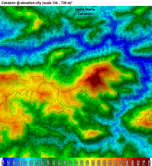
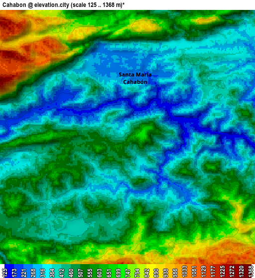
Below is the Elevation map of Cahabón, which displays elevation range with different colors. Scale of the first map is from 134 to 739 m (440 to 2425 ft) with average elevation of 350.2 meters (=1149 ft) [note 1]
These maps also provides idea of topography and contour of this city, they are displayed at different zoom levels. More info about maps, scale and edge coordinates you can find below images.
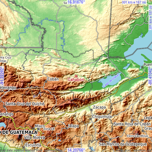
| \ | Map #1 | Map #2 | Topo.Map |
| Scale [m] | 134..739 m | 125..1368 m | × |
| Scale [ft] | 440..2425 ft | 410..4488 ft | × |
| Average | 350.2 m = 1149 ft | 497.6 m = 1633 ft | × |
| Width | 9.41 km = 5.8 mi | 18.83 km = 11.7 mi | 301.2 km = 187.2 mi |
| Height | 9.41 km = 5.8 mi | 18.83 km = 11.7 mi | 301.2 km = 187.2 mi |
| ↑Max Latitude | 15.608999° | 15.651319° | 16.91676° |
| Latitude at center | 15.56667° | 15.56667° | 15.56667° |
| ↓Min Latitude | 15.524332° | 15.481986° | 14.20766° |
| ← Min Longitude | -89.860615° | -89.904561° | -91.22292° |
| Longitude center | -89.81667° | -89.81667° | -89.81667° |
| →Max Longitude | -89.772725° | -89.728779° | -88.41042° |
Nearby cities:
Cities around Cahabón sort by population:
• Panzós elevation 175 m
24.5 km,  139°
139°
• El Estor 92 m
50.1 km,  94°
94°
• San Pedro Carchá 1278 m
49.1 km,  259°
259°
• Chahal Guatemala 178 m
33.7 km,  42°
42°
• Senahú 1323 m
18.6 km,  185°
185°
• Purulhá 2084 m
52.9 km,  230°
230°
• Tucurú 570 m
40 km,  222°
222°
• Lanquín 556 m
16.1 km,  270°
270°
• Tamahú 1095 m
53.3 km,  237°
237°
• Raxruhá 146 m
40.6 km,  325°
325°
• Fray Bartolomé de Las Casas 180 m
28.7 km,  344°
344°
• La Tinta 100 m
28.7 km, 194°
Multilingual:
 En español:
Cahabón elevación 522 m.
 En France:
Cahabón élévation 522 m.


Sources and notes:
- [note 1] Map square and city borders are not equal. Map elevation data is calculated only from area inside that square.
- [src 1] Elevation data from geonames database provided with same terms of usage.
- [src 2] The elevation map of Cahabón is generated using elevation data from NASA's 3 arcsec (90m) resolution SRTM data.
- [src 3] Base (background) map © OpenStreetMap contributors tiles are generated by Geofabrik and OpenTopoMap.
Copyright & License:
This Cahabón Elevation Map is licensed under CC BY-SA. You may reuse any part from this page, if you give a proper credit by linking to this URL:
 More info on terms of use page.