Cuilco elevation
Cuilco (Huehuetenango), Guatemala elevation is 1148 meters and Cuilco elevation in feet is 3766 ft above sea level [src 1]. Cuilco is a seat of a second-order administrative division (feature code) with elevation that is 119 meters (390 ft) smaller than average city elevation in Guatemala.
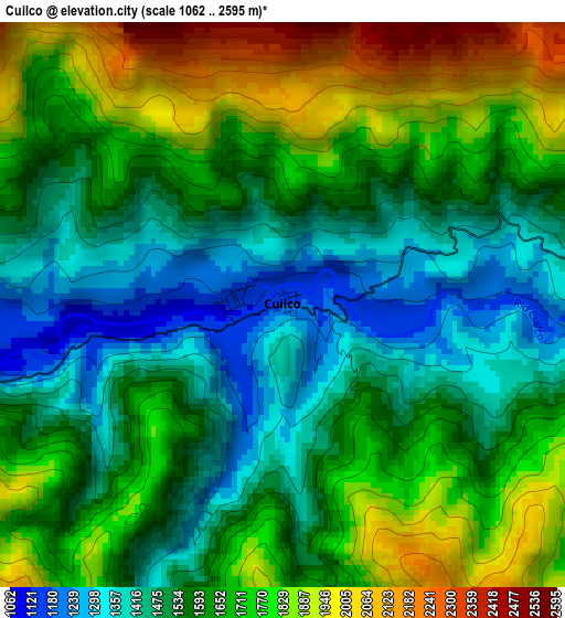
Below is the Elevation map of Cuilco, which displays elevation range with different colors. Scale of the first map is from 1062 to 2595 m (3484 to 8514 ft) with average elevation of 1624 meters (=5328 ft) [note 1]
These maps also provides idea of topography and contour of this city, they are displayed at different zoom levels. More info about maps, scale and edge coordinates you can find below images.
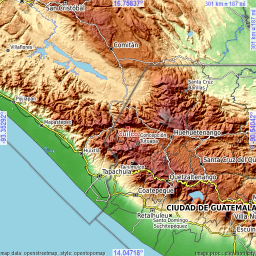
| \ | Map #1 | Topo.Map |
| Scale [m] | 1062..2595 m | × |
| Scale [ft] | 3484..8514 ft | × |
| Average | 1624 m = 5328 ft | × |
| Width | 9.42 km = 5.9 mi | 301.5 km = 187.3 mi |
| Height | 9.42 km = 5.9 mi | 301.5 km = 187.3 mi |
| ↑Max Latitude | 15.449552° | 16.75837° |
| Latitude at center | 15.40719° | 15.40719° |
| ↓Min Latitude | 15.36482° | 14.04718° |
| ← Min Longitude | -91.990615° | -93.35292° |
| Longitude center | -91.94667° | -91.94667° |
| →Max Longitude | -91.902725° | -90.54042° |
Nearby cities:
Cities around Cuilco sort by population:
• La Libertad elevation 1710 m
14.5 km,  34°
34°
• Tacaná 2427 m
22.6 km,  214°
214°
• Ixtahuacán 1609 m
19 km,  86°
86°
• San Miguel Ixtahuacán 2057 m
26.1 km,  125°
125°
• San Pedro Necta 1513 m
21.6 km,  64°
64°
• Colotenango 1596 m
25.1 km, 90°
• San José Ojetenán 3254 m
21.3 km,  185°
185°
• Concepción Tutuapa 2922 m
21.6 km,  149°
149°
• Tectitán 2210 m
16.6 km,  227°
227°
• San Gaspar Ixchil 1391 m
23.8 km,  95°
95°
• La Democracia 928 m
25.1 km,  14°
14°
• San José Ojetenam 3056 m
19.4 km, 188°
Multilingual:
 En español:
Cuilco elevación 1148 m.
 En France:
Cuilco élévation 1148 m.


Sources and notes:
- [note 1] Map square and city borders are not equal. Map elevation data is calculated only from area inside that square.
- [src 1] Elevation data from geonames database provided with same terms of usage.
- [src 2] The elevation map of Cuilco is generated using elevation data from NASA's 3 arcsec (90m) resolution SRTM data.
- [src 3] Base (background) map © OpenStreetMap contributors tiles are generated by Geofabrik and OpenTopoMap.
Copyright & License:
This Cuilco Elevation Map is licensed under CC BY-SA. You may reuse any part from this page, if you give a proper credit by linking to this URL:
 More info on terms of use page.