Flores Costa Cuca elevation
Flores Costa Cuca (Quetzaltenango), Guatemala elevation is 316 meters and Flores Costa Cuca elevation in feet is 1037 ft above sea level [src 1]. Flores Costa Cuca is a populated place (feature code) with elevation that is 951 meters (3120 ft) smaller than average city elevation in Guatemala.
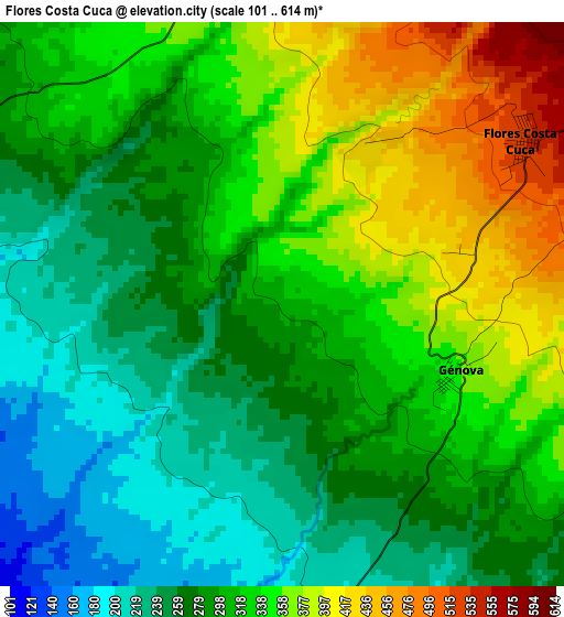
Below is the Elevation map of Flores Costa Cuca, which displays elevation range with different colors. Scale of the first map is from 101 to 614 m (331 to 2014 ft) with average elevation of 309.9 meters (=1017 ft) [note 1]
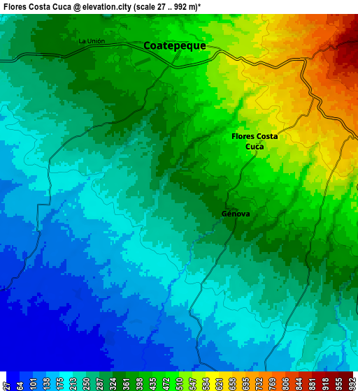
These maps also provides idea of topography and contour of this city, they are displayed at different zoom levels. More info about maps, scale and edge coordinates you can find below images.
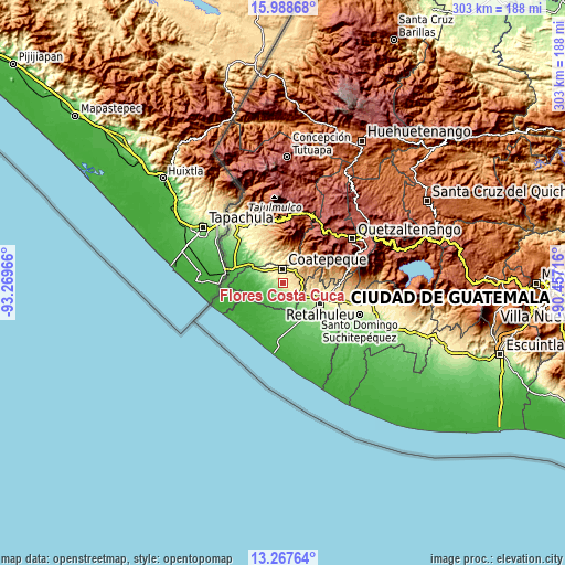
| \ | Map #1 | Map #2 | Topo.Map |
| Scale [m] | 101..614 m | 27..992 m | × |
| Scale [ft] | 331..2014 ft | 89..3255 ft | × |
| Average | 309.9 m = 1017 ft | 320.7 m = 1052 ft | × |
| Width | 9.46 km = 5.9 mi | 18.91 km = 11.8 mi | 302.6 km = 188 mi |
| Height | 9.46 km = 5.9 mi | 18.91 km = 11.8 mi | 302.6 km = 188 mi |
| ↑Max Latitude | 14.674896° | 14.717404° | 15.98868° |
| Latitude at center | 14.63238° | 14.63238° | 14.63238° |
| ↓Min Latitude | 14.589856° | 14.547324° | 13.26764° |
| ← Min Longitude | -91.907355° | -91.951301° | -93.26966° |
| Longitude center | -91.86341° | -91.86341° | -91.86341° |
| →Max Longitude | -91.819465° | -91.775519° | -90.45716° |
Nearby cities:
Cities around Flores Costa Cuca sort by population:
• Coatepeque elevation 492 m
8 km,  359°
359°
• Retalhuleu 241 m
22.7 km,  118°
118°
• Nuevo San Carlos 376 m
18.8 km,  103°
103°
• Colomba 991 m
16.4 km,  59°
59°
• San Sebastián 310 m
24.4 km,  108°
108°
• El Quetzal 784 m
15.9 km,  18°
18°
• Pajapita 99 m
21 km,  298°
298°
• Nuevo Progreso 606 m
18.7 km,  341°
341°
• El Asintal 371 m
15.2 km, 105°
• La Reforma 1127 m
19.3 km,  13°
13°
• Génova 352 m
3.7 km, 118°
• Santa Cruz Muluá 392 m
26.3 km, 102°
Multilingual:
 En español:
Flores Costa Cuca elevación 316 m.
 En France:
Flores Costa Cuca élévation 316 m.
 Auf Deutsch:
Flores Costa Cuca höhe über dem Meeresspiegel ist 316 m.

Sources and notes:
- [note 1] Map square and city borders are not equal. Map elevation data is calculated only from area inside that square.
- [src 1] Elevation data from geonames database provided with same terms of usage.
- [src 2] The elevation map of Flores Costa Cuca is generated using elevation data from NASA's 3 arcsec (90m) resolution SRTM data.
- [src 3] Base (background) map © OpenStreetMap contributors tiles are generated by Geofabrik and OpenTopoMap.
Copyright & License:
This Flores Costa Cuca Elevation Map is licensed under CC BY-SA. You may reuse any part from this page, if you give a proper credit by linking to this URL:
 More info on terms of use page.