Huitán elevation
Huitán (Quetzaltenango), Guatemala elevation is 2615 meters and Huitán elevation in feet is 8579 ft above sea level [src 1]. Huitán is a seat of a second-order administrative division (feature code) with elevation that is 1348 meters (4423 ft) bigger than average city elevation in Guatemala.
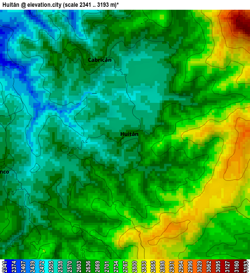
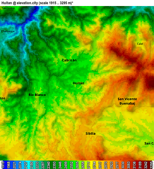
Below is the Elevation map of Huitán, which displays elevation range with different colors. Scale of the first map is from 2341 to 3193 m (7680 to 10476 ft) with average elevation of 2654.5 meters (=8709 ft) [note 1]
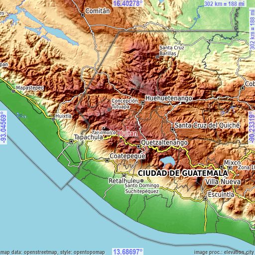
These maps also provides idea of topography and contour of this city, they are displayed at different zoom levels. More info about maps, scale and edge coordinates you can find below images.
| \ | Map #1 | Map #2 | Topo.Map |
| Scale [m] | 2341..3193 m | 1915..3295 m | × |
| Scale [ft] | 7680..10476 ft | 6283..10810 ft | × |
| Average | 2654.5 m = 8709 ft | 2649.6 m = 8693 ft | × |
| Width | 9.44 km = 5.9 mi | 18.87 km = 11.7 mi | 302 km = 187.7 mi |
| Height | 9.44 km = 5.9 mi | 18.87 km = 11.7 mi | 302 km = 187.7 mi |
| ↑Max Latitude | 15.091634° | 15.134059° | 16.40278° |
| Latitude at center | 15.0492° | 15.0492° | 15.0492° |
| ↓Min Latitude | 15.006758° | 14.964307° | 13.68697° |
| ← Min Longitude | -91.683385° | -91.727331° | -93.04569° |
| Longitude center | -91.63944° | -91.63944° | -91.63944° |
| →Max Longitude | -91.595495° | -91.551549° | -90.23319° |
Nearby cities:
Cities around Huitán sort by population:
• San Pedro Sacatepéquez elevation 2412 m
15.9 km,  235°
235°
• Comitancillo 2271 m
12.7 km,  290°
290°
• Cabricán 2617 m
3 km,  342°
342°
• San Miguel Sigüilá 2485 m
17.3 km,  171°
171°
• San Carlos Sija 2730 m
12.1 km,  126°
126°
• Cajolá 2496 m
14.4 km, 169°
• Palestina de los Altos 2627 m
14.1 km,  204°
204°
• San Antonio Sacatepéquez 2410 m
14 km,  225°
225°
• Sibilia 2764 m
6.4 km,  164°
164°
• San Francisco la Unión 2749 m
17.5 km,  143°
143°
• San Lorenzo 2644 m
10.5 km,  258°
258°
• Río Blanco 2626 m
5 km, 255°
Multilingual:
 En español:
Huitán elevación 2615 m.
 En France:
Huitán élévation 2615 m.


Sources and notes:
- [note 1] Map square and city borders are not equal. Map elevation data is calculated only from area inside that square.
- [src 1] Elevation data from geonames database provided with same terms of usage.
- [src 2] The elevation map of Huitán is generated using elevation data from NASA's 3 arcsec (90m) resolution SRTM data.
- [src 3] Base (background) map © OpenStreetMap contributors tiles are generated by Geofabrik and OpenTopoMap.
Copyright & License:
This Huitán Elevation Map is licensed under CC BY-SA. You may reuse any part from this page, if you give a proper credit by linking to this URL:
 More info on terms of use page.