San Miguel Sigüilá elevation
San Miguel Sigüilá (Quetzaltenango), Guatemala elevation is 2485 meters and San Miguel Sigüilá elevation in feet is 8153 ft above sea level [src 1]. San Miguel Sigüilá is a seat of a second-order administrative division (feature code) with elevation that is 1218 meters (3996 ft) bigger than average city elevation in Guatemala.
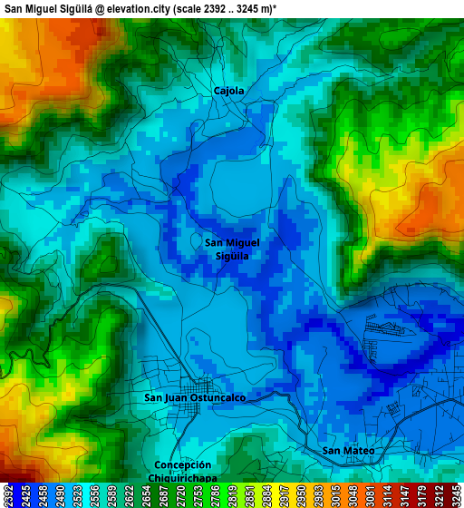
Below is the Elevation map of San Miguel Sigüilá, which displays elevation range with different colors. Scale of the first map is from 2392 to 3245 m (7848 to 10646 ft) with average elevation of 2623 meters (=8606 ft) [note 1]
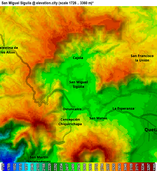
These maps also provides idea of topography and contour of this city, they are displayed at different zoom levels. More info about maps, scale and edge coordinates you can find below images.
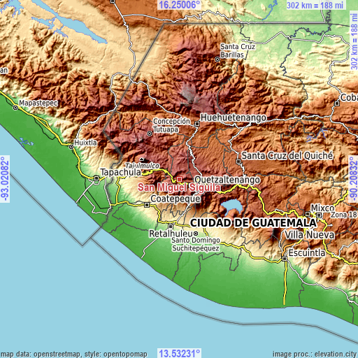
| \ | Map #1 | Map #2 | Topo.Map |
| Scale [m] | 2392..3245 m | 1726..3360 m | × |
| Scale [ft] | 7848..10646 ft | 5663..11024 ft | × |
| Average | 2623 m = 8606 ft | 2698.7 m = 8854 ft | × |
| Width | 9.44 km = 5.9 mi | 18.89 km = 11.7 mi | 302.2 km = 187.8 mi |
| Height | 9.44 km = 5.9 mi | 18.89 km = 11.7 mi | 302.2 km = 187.8 mi |
| ↑Max Latitude | 14.937934° | 14.98039° | 16.25006° |
| Latitude at center | 14.89547° | 14.89547° | 14.89547° |
| ↓Min Latitude | 14.852997° | 14.810516° | 13.53231° |
| ← Min Longitude | -91.658515° | -91.702461° | -93.02082° |
| Longitude center | -91.61457° | -91.61457° | -91.61457° |
| →Max Longitude | -91.570625° | -91.526679° | -90.20832° |
Nearby cities:
Cities around San Miguel Sigüilá sort by population:
• Ostuncalco elevation 2498 m
3 km,  193°
193°
• La Esperanza 2455 m
6.3 km,  114°
114°
• Concepción Chiquirichapa 2572 m
4.6 km, 192°
• San Carlos Sija 2730 m
12.1 km,  35°
35°
• San Mateo 2576 m
4.9 km,  147°
147°
• San Martín Sacatepéquez 2505 m
8.4 km,  200°
200°
• Cajolá 2496 m
3 km,  359°
359°
• Palestina de los Altos 2627 m
9.5 km,  296°
296°
• Sibilia 2764 m
11 km,  354°
354°
• San Francisco la Unión 2749 m
8.4 km,  68°
68°
• Olintepeque 2384 m
10.8 km,  95°
95°
• San Juan Ostuncalco 2791 m
8.4 km,  253°
253°
Multilingual:
 En español:
San Miguel Sigüilá elevación 2485 m.
 En France:
San Miguel Sigüilá élévation 2485 m.
 Auf Deutsch:
San Miguel Sigüilá höhe über dem Meeresspiegel ist 2485 m.
 На русском:
San Miguel Sigüilá высота над уровнем моря 2485 м
Sources and notes:
- [note 1] Map square and city borders are not equal. Map elevation data is calculated only from area inside that square.
- [src 1] Elevation data from geonames database provided with same terms of usage.
- [src 2] The elevation map of San Miguel Sigüilá is generated using elevation data from NASA's 3 arcsec (90m) resolution SRTM data.
- [src 3] Base (background) map © OpenStreetMap contributors tiles are generated by Geofabrik and OpenTopoMap.
Copyright & License:
This San Miguel Sigüilá Elevation Map is licensed under CC BY-SA. You may reuse any part from this page, if you give a proper credit by linking to this URL:
 More info on terms of use page.