Patzún elevation
Patzún (Chimaltenango), Guatemala elevation is 2222 meters and Patzún elevation in feet is 7290 ft above sea level [src 1]. Patzún is a seat of a second-order administrative division (feature code) with elevation that is 955 meters (3133 ft) bigger than average city elevation in Guatemala.
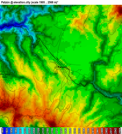
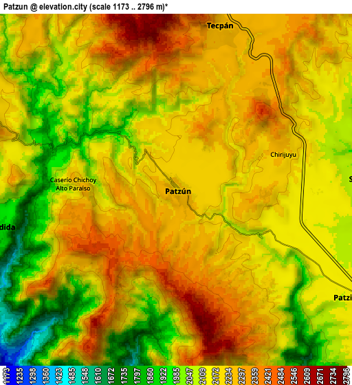
Below is the Elevation map of Patzún, which displays elevation range with different colors. Scale of the first map is from 1905 to 2568 m (6250 to 8425 ft) with average elevation of 2229.2 meters (=7314 ft) [note 1]
These maps also provides idea of topography and contour of this city, they are displayed at different zoom levels. More info about maps, scale and edge coordinates you can find below images.
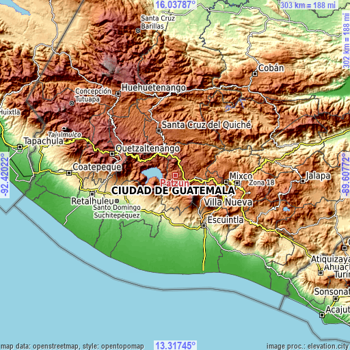
| \ | Map #1 | Map #2 | Topo.Map |
| Scale [m] | 1905..2568 m | 1173..2796 m | × |
| Scale [ft] | 6250..8425 ft | 3848..9173 ft | × |
| Average | 2229.2 m = 7314 ft | 2166.7 m = 7109 ft | × |
| Width | 9.45 km = 5.9 mi | 18.91 km = 11.8 mi | 302.5 km = 188 mi |
| Height | 9.45 km = 5.9 mi | 18.91 km = 11.8 mi | 302.5 km = 188 mi |
| ↑Max Latitude | 14.724396° | 14.766894° | 16.03787° |
| Latitude at center | 14.68189° | 14.68189° | 14.68189° |
| ↓Min Latitude | 14.639375° | 14.596853° | 13.31745° |
| ← Min Longitude | -91.057915° | -91.101861° | -92.42022° |
| Longitude center | -91.01397° | -91.01397° | -91.01397° |
| →Max Longitude | -90.970025° | -90.926079° | -89.60772° |
Nearby cities:
Cities around Patzún sort by population:
• Tecpán Guatemala elevation 2316 m
9.2 km,  14°
14°
• Comalapa 2115 m
15.1 km,  64°
64°
• Patzicía 2129 m
10.9 km,  120°
120°
• San Lucas Tolimán 1576 m
17.2 km,  235°
235°
• Panajachel 1612 m
16.7 km,  293°
293°
• Zaragoza 2083 m
13.8 km,  105°
105°
• Santa Cruz Balanyá 2036 m
10.2 km,  87°
87°
• Acatenango 1486 m
16.1 km,  151°
151°
• San Antonio Palopó 1773 m
11.1 km,  276°
276°
• Santa Catarina Palopó 1573 m
13.7 km, 289°
• San Andrés Semetabaj 1861 m
14.6 km,  298°
298°
• Santa Apolonia 2309 m
12.9 km,  20°
20°
Multilingual:
 En español:
Patzún elevación 2222 m.
 En France:
Patzún élévation 2222 m.


Sources and notes:
- [note 1] Map square and city borders are not equal. Map elevation data is calculated only from area inside that square.
- [src 1] Elevation data from geonames database provided with same terms of usage.
- [src 2] The elevation map of Patzún is generated using elevation data from NASA's 3 arcsec (90m) resolution SRTM data.
- [src 3] Base (background) map © OpenStreetMap contributors tiles are generated by Geofabrik and OpenTopoMap.
Copyright & License:
This Patzún Elevation Map is licensed under CC BY-SA. You may reuse any part from this page, if you give a proper credit by linking to this URL:
 More info on terms of use page.