San Antonio Palopó elevation
San Antonio Palopó (Sololá), Guatemala elevation is 1773 meters and San Antonio Palopó elevation in feet is 5817 ft above sea level [src 1]. San Antonio Palopó is a seat of a second-order administrative division (feature code) with elevation that is 506 meters (1660 ft) bigger than average city elevation in Guatemala.
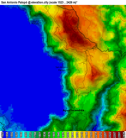
Below is the Elevation map of San Antonio Palopó, which displays elevation range with different colors. Scale of the first map is from 1523 to 2426 m (4997 to 7959 ft) with average elevation of 1819.6 meters (=5970 ft) [note 1]
These maps also provides idea of topography and contour of this city, they are displayed at different zoom levels. More info about maps, scale and edge coordinates you can find below images.
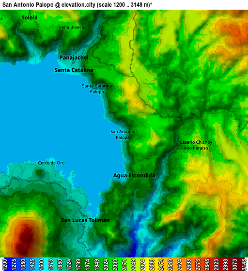
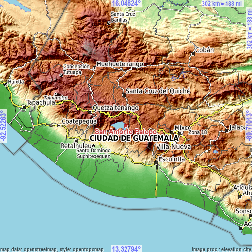
| \ | Map #1 | Map #2 | Topo.Map |
| Scale [m] | 1523..2426 m | 1200..3148 m | × |
| Scale [ft] | 4997..7959 ft | 3937..10328 ft | × |
| Average | 1819.6 m = 5970 ft | 1937 m = 6355 ft | × |
| Width | 9.45 km = 5.9 mi | 18.91 km = 11.8 mi | 302.5 km = 188 mi |
| Height | 9.45 km = 5.9 mi | 18.91 km = 11.8 mi | 302.5 km = 188 mi |
| ↑Max Latitude | 14.734824° | 14.77732° | 16.04824° |
| Latitude at center | 14.69232° | 14.69232° | 14.69232° |
| ↓Min Latitude | 14.649807° | 14.607287° | 13.32794° |
| ← Min Longitude | -91.160325° | -91.204271° | -92.52263° |
| Longitude center | -91.11638° | -91.11638° | -91.11638° |
| →Max Longitude | -91.072435° | -91.028489° | -89.71013° |
Nearby cities:
Cities around San Antonio Palopó sort by population:
• Sololá elevation 2126 m
11.4 km,  320°
320°
• Santiago Atitlán 1603 m
13.5 km,  243°
243°
• Tecpán Guatemala 2316 m
15.4 km,  59°
59°
• Patzún 2222 m
11.1 km,  96°
96°
• San Lucas Tolimán 1576 m
11.3 km,  196°
196°
• Panajachel 1612 m
7 km, 321°
• Concepción 2072 m
10.7 km,  341°
341°
• Santa Catarina Palopó 1573 m
4 km,  330°
330°
• San Marcos La Laguna 1723 m
15.7 km,  283°
283°
• San Andrés Semetabaj 1861 m
6.1 km, 342°
• Santa Cruz La Laguna 1760 m
11.3 km,  300°
300°
• San José Chacayá 2177 m
13.8 km,  309°
309°
Multilingual:
 En español:
San Antonio Palopó elevación 1773 m.
 En France:
San Antonio Palopó élévation 1773 m.
 Auf Deutsch:
San Antonio Palopó höhe über dem Meeresspiegel ist 1773 m.
 На русском:
San Antonio Palopó высота над уровнем моря 1773 м
Sources and notes:
- [note 1] Map square and city borders are not equal. Map elevation data is calculated only from area inside that square.
- [src 1] Elevation data from geonames database provided with same terms of usage.
- [src 2] The elevation map of San Antonio Palopó is generated using elevation data from NASA's 3 arcsec (90m) resolution SRTM data.
- [src 3] Base (background) map © OpenStreetMap contributors tiles are generated by Geofabrik and OpenTopoMap.
Copyright & License:
This San Antonio Palopó Elevation Map is licensed under CC BY-SA. You may reuse any part from this page, if you give a proper credit by linking to this URL:
 More info on terms of use page.