San Pedro La Laguna elevation
San Pedro La Laguna (Sololá), Guatemala elevation is 1590 meters and San Pedro La Laguna elevation in feet is 5217 ft above sea level [src 1]. San Pedro La Laguna is a populated place (feature code) with elevation that is 323 meters (1060 ft) bigger than average city elevation in Guatemala.
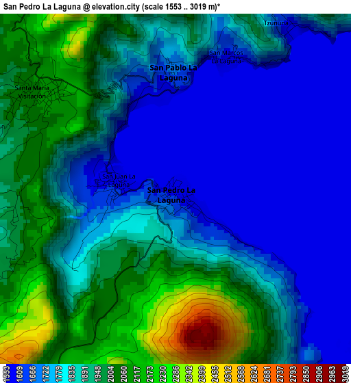
Below is the Elevation map of San Pedro La Laguna, which displays elevation range with different colors. Scale of the first map is from 1553 to 3019 m (5095 to 9905 ft) with average elevation of 1845.8 meters (=6056 ft) [note 1]
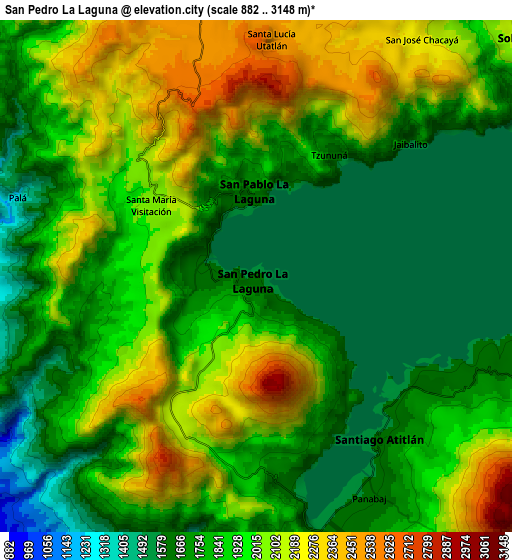
These maps also provides idea of topography and contour of this city, they are displayed at different zoom levels. More info about maps, scale and edge coordinates you can find below images.

| \ | Map #1 | Map #2 | Topo.Map |
| Scale [m] | 1553..3019 m | 882..3148 m | × |
| Scale [ft] | 5095..9905 ft | 2894..10328 ft | × |
| Average | 1845.8 m = 6056 ft | 1902.6 m = 6242 ft | × |
| Width | 9.45 km = 5.9 mi | 18.91 km = 11.8 mi | 302.5 km = 188 mi |
| Height | 9.45 km = 5.9 mi | 18.91 km = 11.8 mi | 302.5 km = 188 mi |
| ↑Max Latitude | 14.735474° | 14.77797° | 16.04888° |
| Latitude at center | 14.69297° | 14.69297° | 14.69297° |
| ↓Min Latitude | 14.650458° | 14.607937° | 13.32859° |
| ← Min Longitude | -91.315955° | -91.359901° | -92.67826° |
| Longitude center | -91.27201° | -91.27201° | -91.27201° |
| →Max Longitude | -91.228065° | -91.184119° | -89.86576° |
Nearby cities:
Cities around San Pedro La Laguna sort by population:
• Sololá elevation 2126 m
13 km,  47°
47°
• Santiago Atitlán 1603 m
7.6 km,  142°
142°
• Santa Catarina Ixtahuacán 2198 m
14.9 km,  321°
321°
• Panajachel 1612 m
13.5 km,  66°
66°
• San Pablo La Laguna 1621 m
3.1 km,  359°
359°
• Santa Clara La Laguna 2075 m
4.2 km,  305°
305°
• San Juan La Laguna 1578 m
1.6 km,  276°
276°
• San Marcos La Laguna 1723 m
3.9 km,  22°
22°
• Santa María Visitación 2010 m
4.8 km,  304°
304°
• Santa Cruz La Laguna 1760 m
9 km, 50°
• Santa Lucía Utatlán 2576 m
8.7 km,  3°
3°
• San José Chacayá 2177 m
10.6 km,  34°
34°
Multilingual:
 En español:
San Pedro La Laguna elevación 1590 m.
 En France:
San Pedro La Laguna élévation 1590 m.
 Auf Deutsch:
San Pedro La Laguna höhe über dem Meeresspiegel ist 1590 m.
 На русском:
San Pedro La Laguna высота над уровнем моря 1590 м
Sources and notes:
- [note 1] Map square and city borders are not equal. Map elevation data is calculated only from area inside that square.
- [src 1] Elevation data from geonames database provided with same terms of usage.
- [src 2] The elevation map of San Pedro La Laguna is generated using elevation data from NASA's 3 arcsec (90m) resolution SRTM data.
- [src 3] Base (background) map © OpenStreetMap contributors tiles are generated by Geofabrik and OpenTopoMap.
Copyright & License:
This San Pedro La Laguna Elevation Map is licensed under CC BY-SA. You may reuse any part from this page, if you give a proper credit by linking to this URL:
 More info on terms of use page.