Evropós elevation
Evropós (Central Macedonia, Nomós Kilkís), Greece elevation is 84 meters and Evropós elevation in feet is 276 ft above sea level [src 1]. Evropós is a populated place (feature code) with elevation that is 67 meters (220 ft) smaller than average city elevation in Greece.
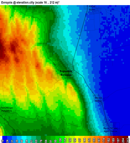
Below is the Elevation map of Evropós, which displays elevation range with different colors. Scale of the first map is from 16 to 212 m (52 to 696 ft) with average elevation of 80.7 meters (=265 ft) [note 1]
These maps also provides idea of topography and contour of this city, they are displayed at different zoom levels. More info about maps, scale and edge coordinates you can find below images.
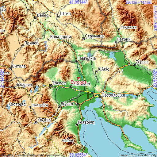
| \ | Map #1 | Topo.Map |
| Scale [m] | 16..212 m | × |
| Scale [ft] | 52..696 ft | × |
| Average | 80.7 m = 265 ft | × |
| Width | 7.39 km = 4.6 mi | 236.4 km = 146.9 mi |
| Height | 7.39 km = 4.6 mi | 236.4 km = 146.9 mi |
| ↑Max Latitude | 40.930239° | 41.95144° |
| Latitude at center | 40.89703° | 40.89703° |
| ↓Min Latitude | 40.863804° | 39.82554° |
| ← Min Longitude | 22.508825° | 21.14652° |
| Longitude center | 22.55277° | 22.55277° |
| →Max Longitude | 22.596715° | 23.95902° |
Nearby cities:
Cities around Evropós sort by population:
• Koufália elevation 47 m
13.4 km,  173°
173°
• Polýkastro 36 m
10.9 km,  7°
7°
• Gouménissa 234 m
10.2 km,  302°
302°
• Axioúpoli 41 m
9.9 km,  354°
354°
• Pélla 62 m
15.2 km,  188°
188°
• Áthyra 28 m
8.6 km,  156°
156°
• Néa Pélla 33 m
15.5 km,  199°
199°
• Ágios Pétros 26 m
4.2 km,  142°
142°
• Próchoma 87 m
14.6 km, 138°
• Néo Agionéri 137 m
16.3 km,  127°
127°
• Ampeleíes 148 m
15.5 km,  243°
243°
• Pentaplátano 135 m
14.2 km,  232°
232°
Multilingual:
 En español:
Evropós elevación 84 m.
 En France:
Evropós élévation 84 m.


Sources and notes:
- [note 1] Map square and city borders are not equal. Map elevation data is calculated only from area inside that square.
- [src 1] Elevation data from geonames database provided with same terms of usage.
- [src 2] The elevation map of Evropós is generated using elevation data from NASA's 3 arcsec (90m) resolution SRTM data.
- [src 3] Base (background) map © OpenStreetMap contributors tiles are generated by Geofabrik and OpenTopoMap.
Copyright & License:
This Evropós Elevation Map is licensed under CC BY-SA. You may reuse any part from this page, if you give a proper credit by linking to this URL:
 More info on terms of use page.