Komniná elevation
Komniná (West Macedonia, Nomós Kozánis), Greece elevation is 683 meters and Komniná elevation in feet is 2241 ft above sea level [src 1]. Komniná is a populated place (feature code) with elevation that is 532 meters (1745 ft) bigger than average city elevation in Greece.
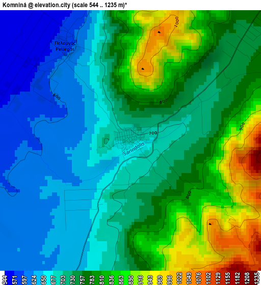
Below is the Elevation map of Komniná, which displays elevation range with different colors. Scale of the first map is from 544 to 1235 m (1785 to 4052 ft) with average elevation of 743.4 meters (=2439 ft) [note 1]
These maps also provides idea of topography and contour of this city, they are displayed at different zoom levels. More info about maps, scale and edge coordinates you can find below images.
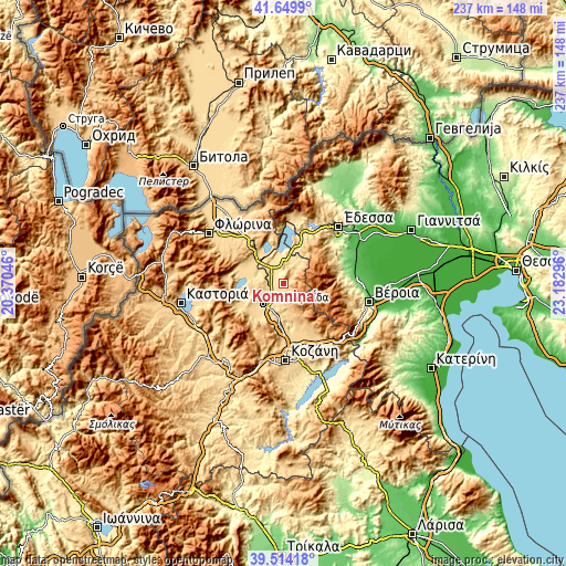
| \ | Map #1 | Topo.Map |
| Scale [m] | 544..1235 m | × |
| Scale [ft] | 1785..4052 ft | × |
| Average | 743.4 m = 2439 ft | × |
| Width | 7.42 km = 4.6 mi | 237.5 km = 147.6 mi |
| Height | 7.42 km = 4.6 mi | 237.5 km = 147.6 mi |
| ↑Max Latitude | 40.623933° | 41.6499° |
| Latitude at center | 40.59057° | 40.59057° |
| ↓Min Latitude | 40.557191° | 39.51418° |
| ← Min Longitude | 21.732765° | 20.37046° |
| Longitude center | 21.77671° | 21.77671° |
| →Max Longitude | 21.820655° | 23.18296° |
Nearby cities:
Cities around Komniná sort by population:
• Ptolemaḯda elevation 609 m
11.8 km,  224°
224°
• Náousa 350 m
25 km,  80°
80°
• Amýntaio 595 m
13.7 km,  323°
323°
• Filótas 565 m
6.9 km,  303°
303°
• Árnissa 554 m
23.3 km,  12°
12°
• Koíla 671 m
28.9 km,  177°
177°
• Kleítos 700 m
19 km,  158°
158°
• Anaráchi 715 m
20.4 km,  237°
237°
• Léchovo 882 m
24 km,  268°
268°
• Akriní 823 m
20.5 km,  147°
147°
• Xinó Neró 647 m
17 km,  310°
310°
• Empório 691 m
21.7 km, 238°
Multilingual:
 En español:
Komniná elevación 683 m.
 En France:
Komniná élévation 683 m.


Sources and notes:
- [note 1] Map square and city borders are not equal. Map elevation data is calculated only from area inside that square.
- [src 1] Elevation data from geonames database provided with same terms of usage.
- [src 2] The elevation map of Komniná is generated using elevation data from NASA's 3 arcsec (90m) resolution SRTM data.
- [src 3] Base (background) map © OpenStreetMap contributors tiles are generated by Geofabrik and OpenTopoMap.
Copyright & License:
This Komniná Elevation Map is licensed under CC BY-SA. You may reuse any part from this page, if you give a proper credit by linking to this URL:
 More info on terms of use page.