Ptolemaḯda elevation
Ptolemaḯda (West Macedonia, Nomós Kozánis), Greece elevation is 609 meters and Ptolemaḯda elevation in feet is 1998 ft above sea level [src 1]. Ptolemaḯda is a seat of a third-order administrative division (feature code) with elevation that is 458 meters (1503 ft) bigger than average city elevation in Greece.
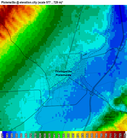
Below is the Elevation map of Ptolemaḯda, which displays elevation range with different colors. Scale of the first map is from 577 to 729 m (1893 to 2392 ft) with average elevation of 614.4 meters (=2016 ft) [note 1]
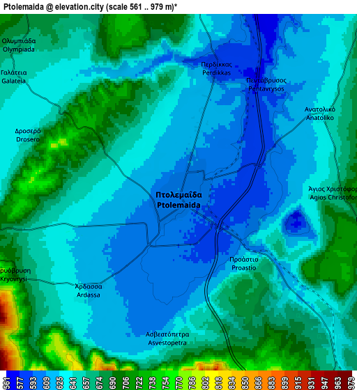
These maps also provides idea of topography and contour of this city, they are displayed at different zoom levels. More info about maps, scale and edge coordinates you can find below images.
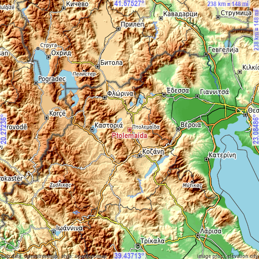
| \ | Map #1 | Map #2 | Topo.Map |
| Scale [m] | 577..729 m | 561..979 m | × |
| Scale [ft] | 1893..2392 ft | 1841..3212 ft | × |
| Average | 614.4 m = 2016 ft | 647.2 m = 2123 ft | × |
| Width | 7.43 km = 4.6 mi | 14.86 km = 9.2 mi | 237.7 km = 147.7 mi |
| Height | 7.43 km = 4.6 mi | 14.86 km = 9.2 mi | 237.7 km = 147.7 mi |
| ↑Max Latitude | 40.548121° | 40.581505° | 41.57527° |
| Latitude at center | 40.51472° | 40.51472° | 40.51472° |
| ↓Min Latitude | 40.481303° | 40.447869° | 39.43713° |
| ← Min Longitude | 21.634665° | 21.590719° | 20.27236° |
| Longitude center | 21.67861° | 21.67861° | 21.67861° |
| →Max Longitude | 21.722555° | 21.766501° | 23.08486° |
Nearby cities:
Cities around Ptolemaḯda sort by population:
• Amýntaio elevation 595 m
19.5 km,  0°
0°
• Galatiní 1004 m
24.2 km,  206°
206°
• Filótas 565 m
12.5 km,  11°
11°
• Koíla 671 m
22.6 km,  155°
155°
• Erátyra 767 m
23.7 km,  216°
216°
• Kleítos 700 m
17.8 km,  121°
121°
• Anaráchi 715 m
9.3 km,  254°
254°
• Komniná 683 m
11.8 km,  44°
44°
• Léchovo 882 m
17.6 km,  296°
296°
• Akriní 823 m
21.2 km,  114°
114°
• Xinó Neró 647 m
20.1 km,  346°
346°
• Empório 691 m
10.6 km, 254°
Multilingual:
 En español:
Ptolemaḯda elevación 609 m.
 En France:
Ptolemaḯda élévation 609 m.
 Auf Deutsch:
Ptolemaida höhe über dem Meeresspiegel ist 609 m.

Sources and notes:
- [note 1] Map square and city borders are not equal. Map elevation data is calculated only from area inside that square.
- [src 1] Elevation data from geonames database provided with same terms of usage.
- [src 2] The elevation map of Ptolemaḯda is generated using elevation data from NASA's 3 arcsec (90m) resolution SRTM data.
- [src 3] Base (background) map © OpenStreetMap contributors tiles are generated by Geofabrik and OpenTopoMap.
Copyright & License:
This Ptolemaḯda Elevation Map is licensed under CC BY-SA. You may reuse any part from this page, if you give a proper credit by linking to this URL:
 More info on terms of use page.