Kopanós elevation
Kopanós (Central Macedonia, Nomós Imathías), Greece elevation is 87 meters and Kopanós elevation in feet is 285 ft above sea level [src 1]. Kopanós is a populated place (feature code) with elevation that is 64 meters (210 ft) smaller than average city elevation in Greece.
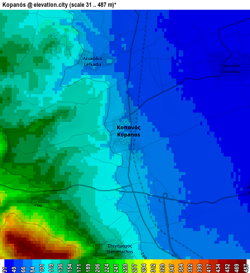
Below is the Elevation map of Kopanós, which displays elevation range with different colors. Scale of the first map is from 31 to 487 m (102 to 1598 ft) with average elevation of 108.3 meters (=355 ft) [note 1]
These maps also provides idea of topography and contour of this city, they are displayed at different zoom levels. More info about maps, scale and edge coordinates you can find below images.
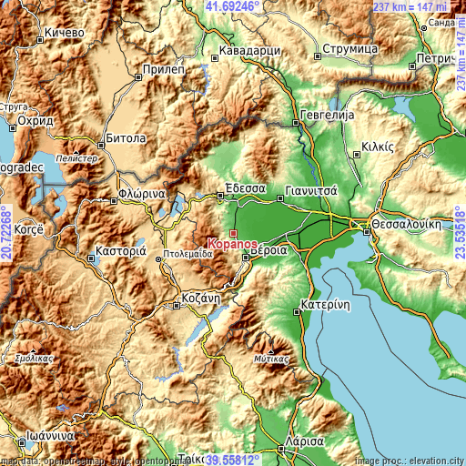
| \ | Map #1 | Topo.Map |
| Scale [m] | 31..487 m | × |
| Scale [ft] | 102..1598 ft | × |
| Average | 108.3 m = 355 ft | × |
| Width | 7.42 km = 4.6 mi | 237.3 km = 147.5 mi |
| Height | 7.42 km = 4.6 mi | 237.3 km = 147.5 mi |
| ↑Max Latitude | 40.667161° | 41.69246° |
| Latitude at center | 40.63382° | 40.63382° |
| ↓Min Latitude | 40.600462° | 39.55812° |
| ← Min Longitude | 22.084985° | 20.72268° |
| Longitude center | 22.12893° | 22.12893° |
| →Max Longitude | 22.172875° | 23.53518° |
Nearby cities:
Cities around Kopanós sort by population:
• Véroia elevation 152 m
13.7 km,  152°
152°
• Náousa 350 m
5.2 km,  264°
264°
• Makrochóri 38 m
13.7 km,  132°
132°
• Eirinoúpoli 24 m
7.3 km,  47°
47°
• Episkopí 70 m
6 km,  6°
6°
• Ágios Geórgios 50 m
6.5 km,  122°
122°
• Angelochóri 21 m
7.8 km, 50°
• Akrolímni 8 m
12.5 km,  65°
65°
• Arsénio 43 m
9.3 km,  15°
15°
• Patrída 109 m
9.4 km, 149°
• Rizó 48 m
11.1 km,  3°
3°
• Marína 132 m
6.9 km,  339°
339°
Multilingual:
 En español:
Kopanós elevación 87 m.
 En France:
Kopanós élévation 87 m.


Sources and notes:
- [note 1] Map square and city borders are not equal. Map elevation data is calculated only from area inside that square.
- [src 1] Elevation data from geonames database provided with same terms of usage.
- [src 2] The elevation map of Kopanós is generated using elevation data from NASA's 3 arcsec (90m) resolution SRTM data.
- [src 3] Base (background) map © OpenStreetMap contributors tiles are generated by Geofabrik and OpenTopoMap.
Copyright & License:
This Kopanós Elevation Map is licensed under CC BY-SA. You may reuse any part from this page, if you give a proper credit by linking to this URL:
 More info on terms of use page.