Véroia elevation
Véroia (Central Macedonia, Nomós Imathías), Greece elevation is 152 meters and Véroia elevation in feet is 499 ft above sea level [src 1]. Véroia is a seat of a second-order administrative division (feature code) with elevation that is 1 meters (3 ft) bigger than average city elevation in Greece.
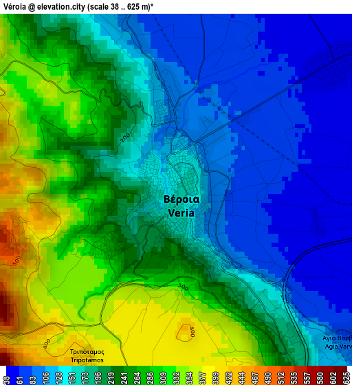
Below is the Elevation map of Véroia, which displays elevation range with different colors. Scale of the first map is from 38 to 625 m (125 to 2051 ft) with average elevation of 204.1 meters (=670 ft) [note 1]
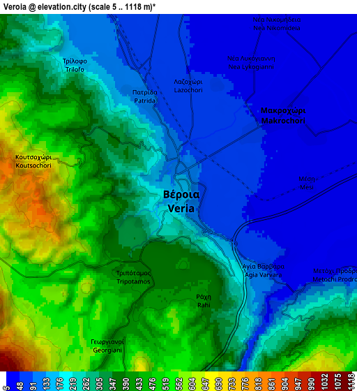
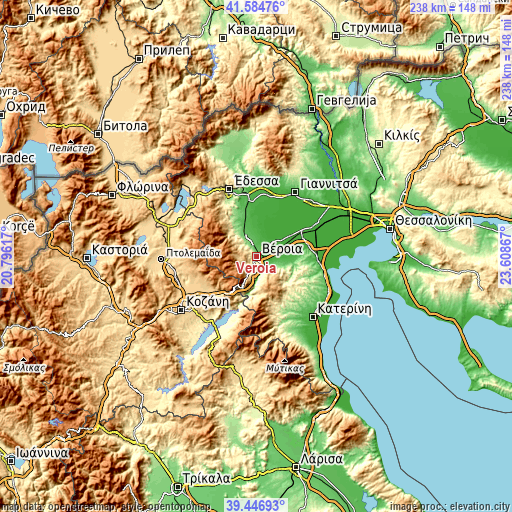
These maps also provides idea of topography and contour of this city, they are displayed at different zoom levels. More info about maps, scale and edge coordinates you can find below images.
| \ | Map #1 | Map #2 | Topo.Map |
| Scale [m] | 38..625 m | 5..1118 m | × |
| Scale [ft] | 125..2051 ft | 16..3668 ft | × |
| Average | 204.1 m = 670 ft | 271.7 m = 891 ft | × |
| Width | 7.43 km = 4.6 mi | 14.86 km = 9.2 mi | 237.7 km = 147.7 mi |
| Height | 7.43 km = 4.6 mi | 14.86 km = 9.2 mi | 237.7 km = 147.7 mi |
| ↑Max Latitude | 40.557766° | 40.591145° | 41.58476° |
| Latitude at center | 40.52437° | 40.52437° | 40.52437° |
| ↓Min Latitude | 40.490958° | 40.457528° | 39.44693° |
| ← Min Longitude | 22.158475° | 22.114529° | 20.79617° |
| Longitude center | 22.20242° | 22.20242° | 22.20242° |
| →Max Longitude | 22.246365° | 22.290311° | 23.60867° |
Nearby cities:
Cities around Véroia sort by population:
• Náousa elevation 350 m
16.3 km,  315°
315°
• Makrochóri 38 m
5 km,  53°
53°
• Melíki 34 m
16.4 km,  92°
92°
• Eirinoúpoli 24 m
17.1 km,  357°
357°
• Kopanós 87 m
13.7 km,  332°
332°
• Ágios Geórgios 50 m
8.7 km, 355°
• Stavrós 10 m
11.5 km, 51°
• Angelochóri 21 m
17.2 km, 359°
• Patrída 109 m
4.3 km,  340°
340°
• Diavatós 25 m
6 km,  66°
66°
• Vergína 111 m
10.6 km,  113°
113°
• Kouloúra 21 m
10.1 km,  75°
75°
Multilingual:
 En español:
Véroia elevación 152 m.
 En France:
Véroia élévation 152 m.


Sources and notes:
- [note 1] Map square and city borders are not equal. Map elevation data is calculated only from area inside that square.
- [src 1] Elevation data from geonames database provided with same terms of usage.
- [src 2] The elevation map of Véroia is generated using elevation data from NASA's 3 arcsec (90m) resolution SRTM data.
- [src 3] Base (background) map © OpenStreetMap contributors tiles are generated by Geofabrik and OpenTopoMap.
Copyright & License:
This Véroia Elevation Map is licensed under CC BY-SA. You may reuse any part from this page, if you give a proper credit by linking to this URL:
 More info on terms of use page.