Sourotí elevation
Sourotí (Central Macedonia, Nomós Thessaloníkis), Greece elevation is 102 meters and Sourotí elevation in feet is 335 ft above sea level [src 1]. Sourotí is a populated place (feature code) with elevation that is 49 meters (161 ft) smaller than average city elevation in Greece.
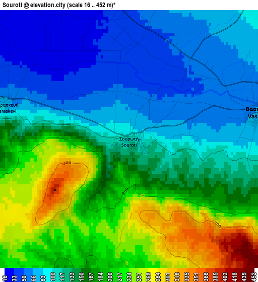
Below is the Elevation map of Sourotí, which displays elevation range with different colors. Scale of the first map is from 16 to 452 m (52 to 1483 ft) with average elevation of 143.7 meters (=471 ft) [note 1]
These maps also provides idea of topography and contour of this city, they are displayed at different zoom levels. More info about maps, scale and edge coordinates you can find below images.
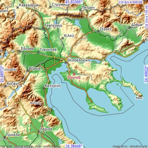
| \ | Map #1 | Topo.Map |
| Scale [m] | 16..452 m | × |
| Scale [ft] | 52..1483 ft | × |
| Average | 143.7 m = 471 ft | × |
| Width | 7.43 km = 4.6 mi | 237.9 km = 147.8 mi |
| Height | 7.43 km = 4.6 mi | 237.9 km = 147.8 mi |
| ↑Max Latitude | 40.506162° | 41.53396° |
| Latitude at center | 40.47274° | 40.47274° |
| ↓Min Latitude | 40.439302° | 39.39448° |
| ← Min Longitude | 23.048025° | 21.68572° |
| Longitude center | 23.09197° | 23.09197° |
| →Max Longitude | 23.135915° | 24.49822° |
Nearby cities:
Cities around Sourotí sort by population:
• Panórama elevation 368 m
13.8 km,  338°
338°
• Thérmi 54 m
10.3 km,  323°
323°
• Trílofos 143 m
10.2 km,  267°
267°
• Plagiári 139 m
11.3 km, 270°
• Vasiliká 68 m
3.9 km,  78°
78°
• Kardiá 184 m
8.3 km, 267°
• Néo Rýsi 43 m
9.2 km,  286°
286°
• Káto Scholári 204 m
7.2 km,  227°
227°
• Agía Paraskeví 82 m
3.8 km,  284°
284°
• Mesiméri 96 m
9.7 km, 227°
• Lákkoma 104 m
9.5 km,  198°
198°
• Peristerá 577 m
10.5 km,  36°
36°
Multilingual:
 En español:
Sourotí elevación 102 m.
 En France:
Sourotí élévation 102 m.


Sources and notes:
- [note 1] Map square and city borders are not equal. Map elevation data is calculated only from area inside that square.
- [src 1] Elevation data from geonames database provided with same terms of usage.
- [src 2] The elevation map of Sourotí is generated using elevation data from NASA's 3 arcsec (90m) resolution SRTM data.
- [src 3] Base (background) map © OpenStreetMap contributors tiles are generated by Geofabrik and OpenTopoMap.
Copyright & License:
This Sourotí Elevation Map is licensed under CC BY-SA. You may reuse any part from this page, if you give a proper credit by linking to this URL:
 More info on terms of use page.