Aígio elevation
Aígio (West Greece, Nomós Achaḯas), Greece elevation is 70 meters and Aígio elevation in feet is 230 ft above sea level [src 1]. Aígio is a seat of a third-order administrative division (feature code) with elevation that is 81 meters (266 ft) smaller than average city elevation in Greece.
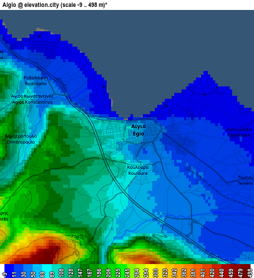
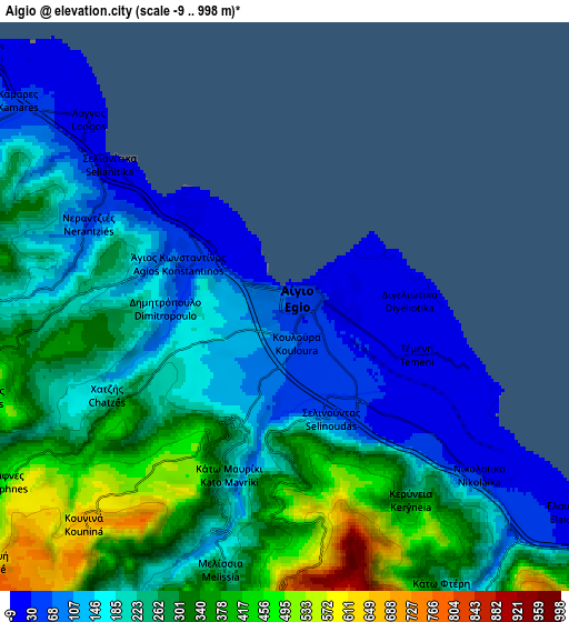
Below is the Elevation map of Aígio, which displays elevation range with different colors. Scale of the first map is from -9 to 498 m (-30 to 1634 ft) with average elevation of 90.2 meters (=296 ft) [note 1]
These maps also provides idea of topography and contour of this city, they are displayed at different zoom levels. More info about maps, scale and edge coordinates you can find below images.
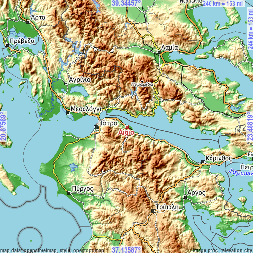
| \ | Map #1 | Map #2 | Topo.Map |
| Scale [m] | -9..498 m | -9..998 m | × |
| Scale [ft] | -30..1634 ft | -30..3274 ft | × |
| Average | 90.2 m = 296 ft | 236.2 m = 775 ft | × |
| Width | 7.67 km = 4.8 mi | 15.35 km = 9.5 mi | 245.6 km = 152.6 mi |
| Height | 7.67 km = 4.8 mi | 15.35 km = 9.5 mi | 245.6 km = 152.6 mi |
| ↑Max Latitude | 38.283113° | 38.317601° | 39.34457° |
| Latitude at center | 38.24861° | 38.24861° | 38.24861° |
| ↓Min Latitude | 38.21409° | 38.179554° | 37.13587° |
| ← Min Longitude | 22.037995° | 21.994049° | 20.67569° |
| Longitude center | 22.08194° | 22.08194° | 22.08194° |
| →Max Longitude | 22.125885° | 22.169831° | 23.48819° |
Nearby cities:
Cities around Aígio sort by population:
• Náfpaktos elevation 3 m
27.3 km,  305°
305°
• Río 33 m
26.4 km,  281°
281°
• Rododáfni 18 m
3.7 km, 309°
• Kalávryta 732 m
24.2 km,  173°
173°
• Sylivainiótika 93 m
23.9 km,  113°
113°
• Aktaío 20 m
25.9 km, 283°
• Aíyira 12 m
26.3 km,  115°
115°
• Akráta 102 m
23.1 km, 116°
• Kamárai 32 m
9.1 km, 307°
• Témeni 13 m
4 km, 108°
• Antirrio 1 m
29.2 km,  288°
288°
• Áno Kastrítsi 491 m
21.6 km, 276°
Multilingual:
 En español:
Aígio elevación 70 m.
 En France:
Aígio élévation 70 m.


Sources and notes:
- [note 1] Map square and city borders are not equal. Map elevation data is calculated only from area inside that square.
- [src 1] Elevation data from geonames database provided with same terms of usage.
- [src 2] The elevation map of Aígio is generated using elevation data from NASA's 3 arcsec (90m) resolution SRTM data.
- [src 3] Base (background) map © OpenStreetMap contributors tiles are generated by Geofabrik and OpenTopoMap.
Copyright & License:
This Aígio Elevation Map is licensed under CC BY-SA. You may reuse any part from this page, if you give a proper credit by linking to this URL:
 More info on terms of use page.