Kalávryta elevation
Kalávryta (West Greece, Nomós Achaḯas), Greece elevation is 732 meters and Kalávryta elevation in feet is 2402 ft above sea level [src 1]. Kalávryta is a seat of a third-order administrative division (feature code) with elevation that is 581 meters (1906 ft) bigger than average city elevation in Greece.
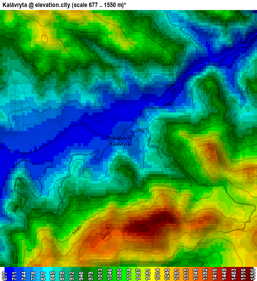
Below is the Elevation map of Kalávryta, which displays elevation range with different colors. Scale of the first map is from 677 to 1550 m (2221 to 5085 ft) with average elevation of 975.9 meters (=3202 ft) [note 1]
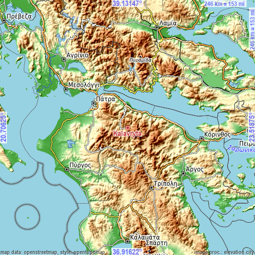
These maps also provides idea of topography and contour of this city, they are displayed at different zoom levels. More info about maps, scale and edge coordinates you can find below images.
| \ | Map #1 | Topo.Map |
| Scale [m] | 677..1550 m | × |
| Scale [ft] | 2221..5085 ft | × |
| Average | 975.9 m = 3202 ft | × |
| Width | 7.7 km = 4.8 mi | 246.3 km = 153 mi |
| Height | 7.7 km = 4.8 mi | 246.3 km = 153 mi |
| ↑Max Latitude | 38.066826° | 39.13147° |
| Latitude at center | 38.03222° | 38.03222° |
| ↓Min Latitude | 37.997598° | 36.91622° |
| ← Min Longitude | 22.068555° | 20.70625° |
| Longitude center | 22.1125° | 22.1125° |
| →Max Longitude | 22.156445° | 23.51875° |
Nearby cities:
Cities around Kalávryta sort by population:
• Aígio elevation 70 m
24.2 km,  353°
353°
• Ovriá 61 m
37.8 km,  297°
297°
• Rododáfni 18 m
27 km, 348°
• Mindilóglion 62 m
39.7 km, 295°
• Sylivainiótika 93 m
24 km,  53°
53°
• Aíyira 12 m
24.8 km,  58°
58°
• Akráta 102 m
22.6 km, 52°
• Langádhia 935 m
39.6 km,  190°
190°
• Kamárai 32 m
31.3 km,  341°
341°
• Témeni 13 m
22.8 km,  2°
2°
• Áno Kastrítsi 491 m
36 km,  317°
317°
• Chalandrítsa 346 m
30 km,  286°
286°
Multilingual:
 En español:
Kalávryta elevación 732 m.
 En France:
Kalávryta élévation 732 m.
 Auf Deutsch:
Kalávryta höhe über dem Meeresspiegel ist 732 m.

Sources and notes:
- [note 1] Map square and city borders are not equal. Map elevation data is calculated only from area inside that square.
- [src 1] Elevation data from geonames database provided with same terms of usage.
- [src 2] The elevation map of Kalávryta is generated using elevation data from NASA's 3 arcsec (90m) resolution SRTM data.
- [src 3] Base (background) map © OpenStreetMap contributors tiles are generated by Geofabrik and OpenTopoMap.
Copyright & License:
This Kalávryta Elevation Map is licensed under CC BY-SA. You may reuse any part from this page, if you give a proper credit by linking to this URL:
 More info on terms of use page.