Maroúsi elevation
Maroúsi (Attica, Nomarchía Athínas), Greece elevation is 220 meters and Maroúsi elevation in feet is 722 ft above sea level [src 1]. Maroúsi is a seat of a third-order administrative division (feature code) with elevation that is 69 meters (226 ft) bigger than average city elevation in Greece.
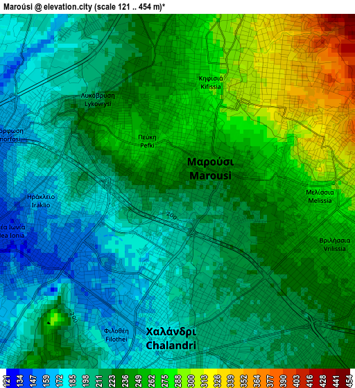
Below is the Elevation map of Maroúsi, which displays elevation range with different colors. Scale of the first map is from 121 to 454 m (397 to 1490 ft) with average elevation of 227.3 meters (=746 ft) [note 1]
These maps also provides idea of topography and contour of this city, they are displayed at different zoom levels. More info about maps, scale and edge coordinates you can find below images.
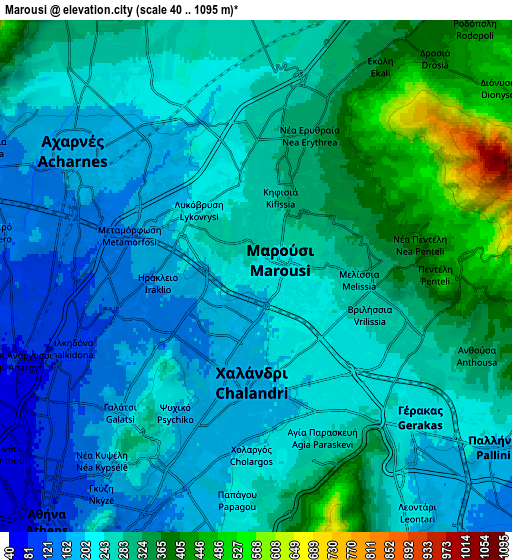
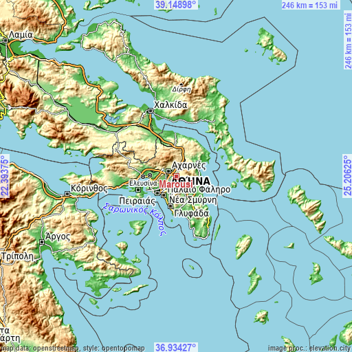
| \ | Map #1 | Map #2 | Topo.Map |
| Scale [m] | 121..454 m | 40..1095 m | × |
| Scale [ft] | 397..1490 ft | 131..3593 ft | × |
| Average | 227.3 m = 746 ft | 261.7 m = 859 ft | × |
| Width | 7.7 km = 4.8 mi | 15.39 km = 9.6 mi | 246.3 km = 153 mi |
| Height | 7.7 km = 4.8 mi | 15.39 km = 9.6 mi | 246.2 km = 153 mi |
| ↑Max Latitude | 38.084598° | 38.119179° | 39.14898° |
| Latitude at center | 38.05° | 38.05° | 38.05° |
| ↓Min Latitude | 38.015386° | 37.980756° | 36.93427° |
| ← Min Longitude | 23.756055° | 23.712109° | 22.39375° |
| Longitude center | 23.8° | 23.8° | 23.8° |
| →Max Longitude | 23.843945° | 23.887891° | 25.20625° |
Nearby cities:
Cities around Maroúsi sort by population:
• Khalándrion elevation 194 m
2.9 km,  178°
178°
• Néa Ionía 152 m
4.1 km,  246°
246°
• Agía Paraskeví 216 m
4.7 km,  141°
141°
• Irákleio 169 m
3.1 km,  275°
275°
• Kifisiá 290 m
2.9 km,  19°
19°
• Vrilissia 232 m
3.2 km,  124°
124°
• Metamórfosi 173 m
3.6 km,  298°
298°
• Melíssia 273 m
2.9 km,  90°
90°
• Péfki 257 m
1.3 km,  330°
330°
• Lykóvrysi 225 m
2.7 km,  324°
324°
• Psychikó 197 m
4.8 km,  210°
210°
• Filothéi 162 m
3.1 km, 209°
Multilingual:
 En español:
Maroúsi elevación 220 m.
 En France:
Maroúsi élévation 220 m.


Sources and notes:
- [note 1] Map square and city borders are not equal. Map elevation data is calculated only from area inside that square.
- [src 1] Elevation data from geonames database provided with same terms of usage.
- [src 2] The elevation map of Maroúsi is generated using elevation data from NASA's 3 arcsec (90m) resolution SRTM data.
- [src 3] Base (background) map © OpenStreetMap contributors tiles are generated by Geofabrik and OpenTopoMap.
Copyright & License:
This Maroúsi Elevation Map is licensed under CC BY-SA. You may reuse any part from this page, if you give a proper credit by linking to this URL:
 More info on terms of use page.