Lamía elevation
Lamía (Central Greece, Nomós Fthiótidos), Greece elevation is 88 meters and Lamía elevation in feet is 289 ft above sea level [src 1]. Lamía is a seat of a first-order administrative division (feature code) with elevation that is 63 meters (207 ft) smaller than average city elevation in Greece.
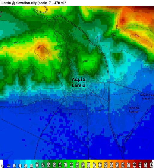
Below is the Elevation map of Lamía, which displays elevation range with different colors. Scale of the first map is from -7 to 470 m (-23 to 1542 ft) with average elevation of 103.8 meters (=341 ft) [note 1]
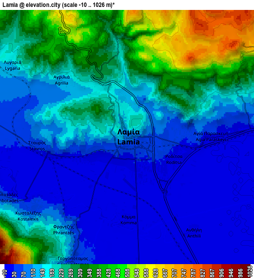
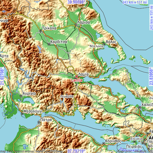
These maps also provides idea of topography and contour of this city, they are displayed at different zoom levels. More info about maps, scale and edge coordinates you can find below images.
| \ | Map #1 | Map #2 | Topo.Map |
| Scale [m] | -7..470 m | -10..1026 m | × |
| Scale [ft] | -23..1542 ft | -33..3366 ft | × |
| Average | 103.8 m = 341 ft | 188 m = 617 ft | × |
| Width | 7.61 km = 4.7 mi | 15.21 km = 9.5 mi | 243.4 km = 151.2 mi |
| Height | 7.61 km = 4.7 mi | 15.21 km = 9.5 mi | 243.4 km = 151.2 mi |
| ↑Max Latitude | 38.934192° | 38.968367° | 39.98595° |
| Latitude at center | 38.9° | 38.9° | 38.9° |
| ↓Min Latitude | 38.865792° | 38.831567° | 37.79719° |
| ← Min Longitude | 22.389385° | 22.345439° | 21.02708° |
| Longitude center | 22.43333° | 22.43333° | 22.43333° |
| →Max Longitude | 22.477275° | 22.521221° | 23.83958° |
Nearby cities:
Cities around Lamía sort by population:
• Stylída elevation 52 m
16 km,  83°
83°
• Rodhítsa 25 m
3 km,  116°
116°
• Amfíkleia 389 m
32.1 km,  154°
154°
• Spercheiáda 207 m
26.4 km,  271°
271°
• Stavrós 62 m
5.4 km, 265°
• Makrakómi 143 m
27.9 km,  279°
279°
• Mólos 35 m
20.9 km, 118°
• Anthíli 8 m
6.8 km,  144°
144°
• Domokós 576 m
27.8 km,  335°
335°
• Omvriakí 560 m
26.4 km,  327°
327°
• Kainoúryion 30 m
27.9 km, 115°
• Lianokládhion 60 m
11.4 km, 279°
Multilingual:
 En español:
Lamía elevación 88 m.
 En France:
Lamía élévation 88 m.


Sources and notes:
- [note 1] Map square and city borders are not equal. Map elevation data is calculated only from area inside that square.
- [src 1] Elevation data from geonames database provided with same terms of usage.
- [src 2] The elevation map of Lamía is generated using elevation data from NASA's 3 arcsec (90m) resolution SRTM data.
- [src 3] Base (background) map © OpenStreetMap contributors tiles are generated by Geofabrik and OpenTopoMap.
Copyright & License:
This Lamía Elevation Map is licensed under CC BY-SA. You may reuse any part from this page, if you give a proper credit by linking to this URL:
 More info on terms of use page.