Amfíkleia elevation
Amfíkleia (Central Greece, Nomós Fthiótidos), Greece elevation is 389 meters and Amfíkleia elevation in feet is 1276 ft above sea level [src 1]. Amfíkleia is a populated place (feature code) with elevation that is 238 meters (781 ft) bigger than average city elevation in Greece.
Below is the Elevation map of Amfíkleia, which displays elevation range with different colors. Scale of the first map is from 192 to 1337 m (630 to 4386 ft) with average elevation of 539.1 meters (=1769 ft) [note 1]
These maps also provides idea of topography and contour of this city, they are displayed at different zoom levels. More info about maps, scale and edge coordinates you can find below images.
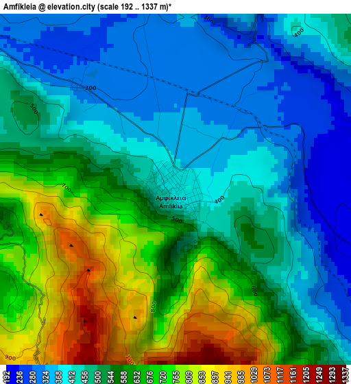
| \ | Map #1 | Topo.Map |
| Scale [m] | 192..1337 m | × |
| Scale [ft] | 630..4386 ft | × |
| Average | 539.1 m = 1769 ft | × |
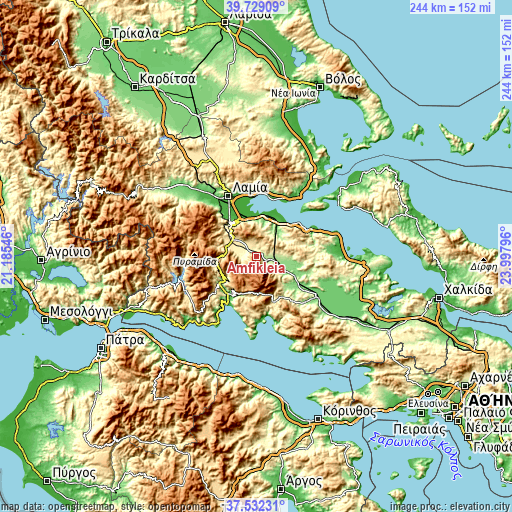
| Width | 7.63 km = 4.7 mi | 244.3 km = 151.8 mi |
| Height | 7.63 km = 4.7 mi | 244.3 km = 151.8 mi |
| ↑Max Latitude | 38.673437° | 39.72909° |
| Latitude at center | 38.63912° | 38.63912° |
| ↓Min Latitude | 38.604786° | 37.53231° |
| ← Min Longitude | 22.547765° | 21.18546° |
| Longitude center | 22.59171° | 22.59171° |
| →Max Longitude | 22.635655° | 23.99796° |
Nearby cities:
Cities around Amfíkleia sort by population:
• Ámfissa elevation 178 m
22.4 km,  236°
236°
• Kaména Voúrla 8 m
22.9 km,  47°
47°
• Káto Tithoréa 162 m
11.1 km,  108°
108°
• Aráchova 941 m
17.8 km,  182°
182°
• Áyios Konstandínos 7 m
26.5 km,  60°
60°
• Delphi 560 m
19.7 km,  205°
205°
• Eláteia 178 m
15.1 km,  94°
94°
• Mólos 35 m
19.6 km,  13°
13°
• Anthíli 8 m
25.4 km,  337°
337°
• Kírra 4 m
26.6 km, 208°
• Kainoúryion 30 m
20.6 km,  34°
34°
• Dístomo 448 m
24.3 km,  164°
164°
Multilingual:
 En español:
Amfíkleia elevación 389 m.
 En France:
Amfíkleia élévation 389 m.
 Auf Deutsch:
Amfíkleia höhe über dem Meeresspiegel ist 389 m.

Sources and notes:
- [note 1] Map square and city borders are not equal. Map elevation data is calculated only from area inside that square.
- [src 1] Elevation data from geonames database provided with same terms of usage.
- [src 2] The elevation map of Amfíkleia is generated using elevation data from NASA's 3 arcsec (90m) resolution SRTM data.
- [src 3] Base (background) map © OpenStreetMap contributors tiles are generated by Geofabrik and OpenTopoMap.
Copyright & License:
This Amfíkleia Elevation Map is licensed under CC BY-SA. You may reuse any part from this page, if you give a proper credit by linking to this URL:
 More info on terms of use page.