Artémida elevation
Artémida (Attica, Nomarchía Anatolikís Attikís), Greece elevation is 37 meters and Artémida elevation in feet is 121 ft above sea level [src 1]. Artémida is a populated place (feature code) with elevation that is 114 meters (374 ft) smaller than average city elevation in Greece.
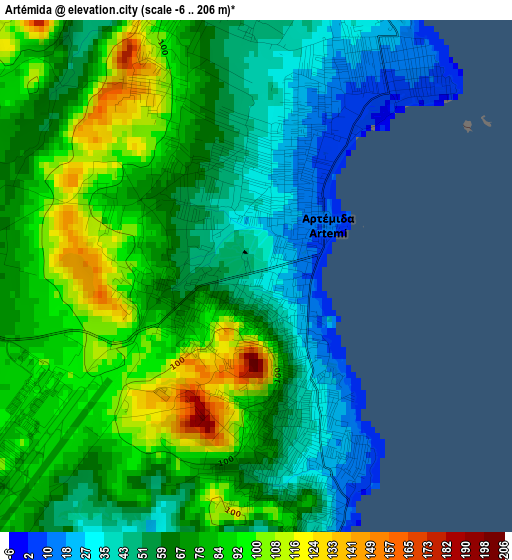
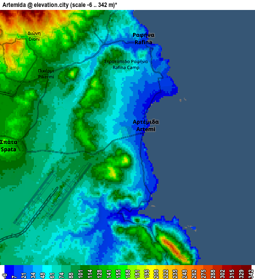
Below is the Elevation map of Artémida, which displays elevation range with different colors. Scale of the first map is from -6 to 206 m (-20 to 676 ft) with average elevation of 69.3 meters (=227 ft) [note 1]
These maps also provides idea of topography and contour of this city, they are displayed at different zoom levels. More info about maps, scale and edge coordinates you can find below images.
| \ | Map #1 | Map #2 | Topo.Map |
| Scale [m] | -6..206 m | -6..342 m | × |
| Scale [ft] | -20..676 ft | -20..1122 ft | × |
| Average | 69.3 m = 227 ft | 87.5 m = 287 ft | × |
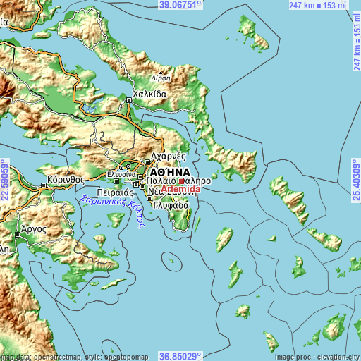
| Width | 7.7 km = 4.8 mi | 15.41 km = 9.6 mi | 246.5 km = 153.2 mi |
| Height | 7.7 km = 4.8 mi | 15.41 km = 9.6 mi | 246.5 km = 153.2 mi |
| ↑Max Latitude | 38.001907° | 38.036527° | 39.06751° |
| Latitude at center | 37.96727° | 37.96727° | 37.96727° |
| ↓Min Latitude | 37.932617° | 37.897948° | 36.85029° |
| ← Min Longitude | 23.952895° | 23.908949° | 22.59059° |
| Longitude center | 23.99684° | 23.99684° | 23.99684° |
| →Max Longitude | 24.040785° | 24.084731° | 25.40309° |
Nearby cities:
Cities around Artémida sort by population:
• Pallíni elevation 199 m
10.8 km,  292°
292°
• Rafína 11 m
5.7 km,  8°
8°
• Limín Mesoyaías 21 m
8.5 km,  176°
176°
• Markópoulo 95 m
10.9 km,  210°
210°
• Spáta 142 m
7.2 km,  264°
264°
• Dhráfi 268 m
10 km,  308°
308°
• Anthoúsa 316 m
12.4 km,  301°
301°
• Dióni 201 m
8.4 km,  318°
318°
• Pikérmi 106 m
6.2 km, 307°
• Karellás 134 m
12.1 km,  252°
252°
• Neos Voutzás 180 m
8.6 km,  348°
348°
• Argithéa 224 m
9.8 km,  275°
275°
Multilingual:
 En español:
Artémida elevación 37 m.
 En France:
Artémida élévation 37 m.


Sources and notes:
- [note 1] Map square and city borders are not equal. Map elevation data is calculated only from area inside that square.
- [src 1] Elevation data from geonames database provided with same terms of usage.
- [src 2] The elevation map of Artémida is generated using elevation data from NASA's 3 arcsec (90m) resolution SRTM data.
- [src 3] Base (background) map © OpenStreetMap contributors tiles are generated by Geofabrik and OpenTopoMap.
Copyright & License:
This Artémida Elevation Map is licensed under CC BY-SA. You may reuse any part from this page, if you give a proper credit by linking to this URL:
 More info on terms of use page.