Ílion elevation
Ílion (Attica, Nomarchía Athínas), Greece elevation is 90 meters and Ílion elevation in feet is 295 ft above sea level [src 1]. Ílion is a seat of a third-order administrative division (feature code) with elevation that is 61 meters (200 ft) smaller than average city elevation in Greece.
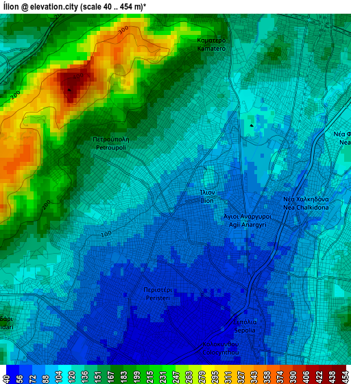
Below is the Elevation map of Ílion, which displays elevation range with different colors. Scale of the first map is from 40 to 454 m (131 to 1490 ft) with average elevation of 134.6 meters (=442 ft) [note 1]
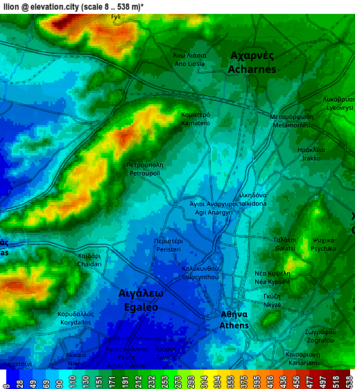
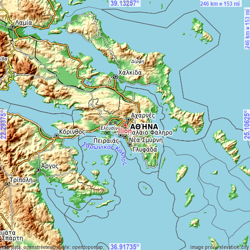
These maps also provides idea of topography and contour of this city, they are displayed at different zoom levels. More info about maps, scale and edge coordinates you can find below images.
| \ | Map #1 | Map #2 | Topo.Map |
| Scale [m] | 40..454 m | 8..538 m | × |
| Scale [ft] | 131..1490 ft | 26..1765 ft | × |
| Average | 134.6 m = 442 ft | 150.2 m = 493 ft | × |
| Width | 7.7 km = 4.8 mi | 15.39 km = 9.6 mi | 246.3 km = 153 mi |
| Height | 7.7 km = 4.8 mi | 15.39 km = 9.6 mi | 246.3 km = 153 mi |
| ↑Max Latitude | 38.067935° | 38.102525° | 39.13257° |
| Latitude at center | 38.03333° | 38.03333° | 38.03333° |
| ↓Min Latitude | 37.998708° | 37.96407° | 36.91735° |
| ← Min Longitude | 23.656055° | 23.612109° | 22.29375° |
| Longitude center | 23.7° | 23.7° | 23.7° |
| →Max Longitude | 23.743945° | 23.787891° | 25.10625° |
Nearby cities:
Cities around Ílion sort by population:
• Peristéri elevation 66 m
2.1 km,  199°
199°
• Néa Ionía 152 m
5 km,  86°
86°
• Galátsi 177 m
4.8 km,  112°
112°
• Petroúpolis 144 m
1.6 km,  305°
305°
• Chaïdári 92 m
3.9 km,  230°
230°
• Ágioi Anárgyroi 84 m
2.1 km,  99°
99°
• Áno Liósia 174 m
5.6 km,  0°
0°
• Kamaterón 142 m
2.5 km,  10°
10°
• Néa Filadélfeia 104 m
3.3 km, 86°
• Néa Chalkidóna 82 m
2.8 km, 104°
• Zefyri 148 m
4 km,  22°
22°
• Kipséli 126 m
4.7 km,  135°
135°
Multilingual:
 En español:
Ílion elevación 90 m.
 En France:
Ílion élévation 90 m.


Sources and notes:
- [note 1] Map square and city borders are not equal. Map elevation data is calculated only from area inside that square.
- [src 1] Elevation data from geonames database provided with same terms of usage.
- [src 2] The elevation map of Ílion is generated using elevation data from NASA's 3 arcsec (90m) resolution SRTM data.
- [src 3] Base (background) map © OpenStreetMap contributors tiles are generated by Geofabrik and OpenTopoMap.
Copyright & License:
This Ílion Elevation Map is licensed under CC BY-SA. You may reuse any part from this page, if you give a proper credit by linking to this URL:
 More info on terms of use page.