Rethymno elevation
Rethymno (Crete, Nomós Rethýmnis), Greece elevation is 14 meters and Rethymno elevation in feet is 46 ft above sea level [src 1]. Rethymno is a seat of a second-order administrative division (feature code) with elevation that is 137 meters (449 ft) smaller than average city elevation in Greece.
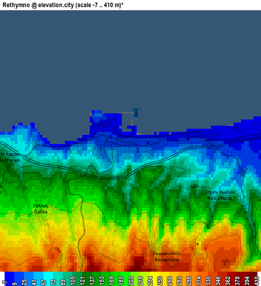
Below is the Elevation map of Rethymno, which displays elevation range with different colors. Scale of the first map is from -7 to 410 m (-23 to 1345 ft) with average elevation of 161.2 meters (=529 ft) [note 1]
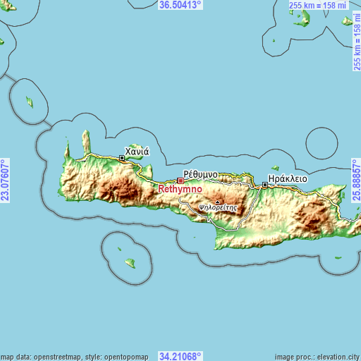
These maps also provides idea of topography and contour of this city, they are displayed at different zoom levels. More info about maps, scale and edge coordinates you can find below images.

| \ | Map #1 | Map #2 | Topo.Map |
| Scale [m] | -7..410 m | -18..837 m | × |
| Scale [ft] | -23..1345 ft | -59..2746 ft | × |
| Average | 161.2 m = 529 ft | 267.3 m = 877 ft | × |
| Width | 7.97 km = 5 mi | 15.94 km = 9.9 mi | 255 km = 158.4 mi |
| Height | 7.97 km = 5 mi | 15.94 km = 9.9 mi | 255 km = 158.4 mi |
| ↑Max Latitude | 35.401378° | 35.437191° | 36.50413° |
| Latitude at center | 35.36555° | 35.36555° | 35.36555° |
| ↓Min Latitude | 35.329706° | 35.293846° | 34.21068° |
| ← Min Longitude | 24.438375° | 24.394429° | 23.07607° |
| Longitude center | 24.48232° | 24.48232° | 24.48232° |
| →Max Longitude | 24.526265° | 24.570211° | 25.88857° |
Nearby cities:
Cities around Rethymno sort by population:
• Violí Charáki elevation 143 m
4 km,  259°
259°
• Georgioupolis 12 m
20.2 km,  268°
268°
• Zonianá 623 m
32.4 km,  103°
103°
• Pérama 74 m
20.1 km,  88°
88°
• Mouzourás 162 m
35.3 km,  303°
303°
• Kalýves 6 m
29.4 km,  288°
288°
• Atsipópoulo 174 m
4.6 km,  251°
251°
• Agía Galíni 25 m
35.2 km,  147°
147°
• Pánormos 13 m
19.8 km,  72°
72°
• Vrýses 61 m
25.5 km, 272°
• Chóra Sfakíon 23 m
36.2 km,  239°
239°
• Agía Foteiní 480 m
18.5 km,  131°
131°
Multilingual:
 En español:
Rétino elevación 14 m.
 En France:
Réthymnon élévation 14 m.
 Auf Deutsch:
Rethymnon höhe über dem Meeresspiegel ist 14 m.

Sources and notes:
- [note 1] Map square and city borders are not equal. Map elevation data is calculated only from area inside that square.
- [src 1] Elevation data from geonames database provided with same terms of usage.
- [src 2] The elevation map of Rethymno is generated using elevation data from NASA's 3 arcsec (90m) resolution SRTM data.
- [src 3] Base (background) map © OpenStreetMap contributors tiles are generated by Geofabrik and OpenTopoMap.
Copyright & License:
This Rethymno Elevation Map is licensed under CC BY-SA. You may reuse any part from this page, if you give a proper credit by linking to this URL:
 More info on terms of use page.