Agía Foteiní elevation
Agía Foteiní (Crete, Nomós Rethýmnis), Greece elevation is 480 meters and Agía Foteiní elevation in feet is 1575 ft above sea level [src 1]. Agía Foteiní is a seat of a third-order administrative division (feature code) with elevation that is 329 meters (1079 ft) bigger than average city elevation in Greece.
Below is the Elevation map of Agía Foteiní, which displays elevation range with different colors. Scale of the first map is from 224 to 1086 m (735 to 3563 ft) with average elevation of 585.6 meters (=1921 ft) [note 1]
These maps also provides idea of topography and contour of this city, they are displayed at different zoom levels. More info about maps, scale and edge coordinates you can find below images.
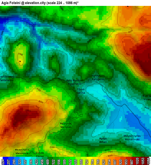
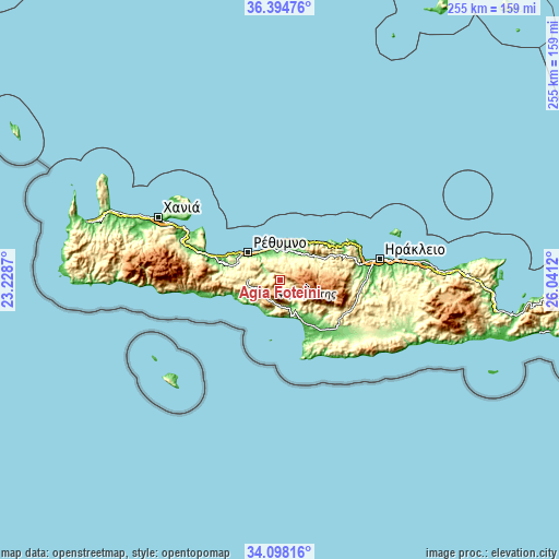
| \ | Map #1 | Topo.Map |
| Scale [m] | 224..1086 m | × |
| Scale [ft] | 735..3563 ft | × |
| Average | 585.6 m = 1921 ft | × |
| Width | 7.98 km = 5 mi | 255.4 km = 158.7 mi |
| Height | 7.98 km = 5 mi | 255.4 km = 158.7 mi |
| ↑Max Latitude | 35.290468° | 36.39476° |
| Latitude at center | 35.25459° | 35.25459° |
| ↓Min Latitude | 35.218697° | 34.09816° |
| ← Min Longitude | 24.591005° | 23.2287° |
| Longitude center | 24.63495° | 24.63495° |
| →Max Longitude | 24.678895° | 26.0412° |
Nearby cities:
Cities around Agía Foteiní sort by population:
• Rethymno elevation 14 m
18.5 km,  311°
311°
• Moíres 84 m
31.3 km,  136°
136°
• Tympáki 25 m
23.6 km,  149°
149°
• Violí Charáki 143 m
21.2 km,  302°
302°
• Anógeia 754 m
23 km,  79°
79°
• Zarós 334 m
28.1 km,  119°
119°
• Zonianá 623 m
18.2 km, 75°
• Pérama 74 m
14.3 km,  25°
25°
• Gérgeri 512 m
31.6 km, 115°
• Atsipópoulo 174 m
21.3 km, 300°
• Agía Galíni 25 m
18.2 km,  164°
164°
• Pánormos 13 m
18.9 km,  15°
15°
Multilingual:
 En español:
Agía Foteiní elevación 480 m.
 En France:
Agía Foteiní élévation 480 m.
 Auf Deutsch:
Agía Foteiní höhe über dem Meeresspiegel ist 480 m.

Sources and notes:
- [note 1] Map square and city borders are not equal. Map elevation data is calculated only from area inside that square.
- [src 1] Elevation data from geonames database provided with same terms of usage.
- [src 2] The elevation map of Agía Foteiní is generated using elevation data from NASA's 3 arcsec (90m) resolution SRTM data.
- [src 3] Base (background) map © OpenStreetMap contributors tiles are generated by Geofabrik and OpenTopoMap.
Copyright & License:
This Agía Foteiní Elevation Map is licensed under CC BY-SA. You may reuse any part from this page, if you give a proper credit by linking to this URL:
 More info on terms of use page.