Týrnavos elevation
Týrnavos (Thessaly, Nomós Larísis), Greece elevation is 94 meters and Týrnavos elevation in feet is 308 ft above sea level [src 1]. Týrnavos is a seat of a third-order administrative division (feature code) with elevation that is 57 meters (187 ft) smaller than average city elevation in Greece.
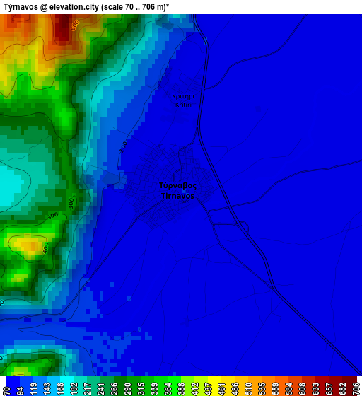
Below is the Elevation map of Týrnavos, which displays elevation range with different colors. Scale of the first map is from 70 to 706 m (230 to 2316 ft) with average elevation of 141.7 meters (=465 ft) [note 1]
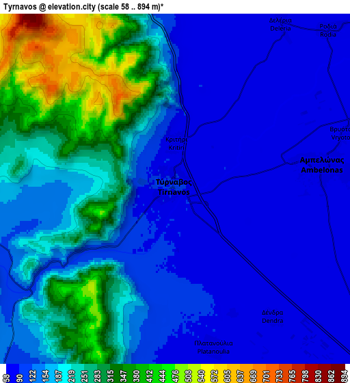
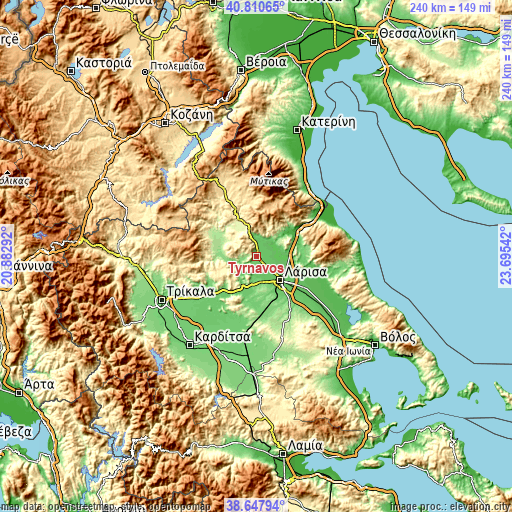
These maps also provides idea of topography and contour of this city, they are displayed at different zoom levels. More info about maps, scale and edge coordinates you can find below images.
| \ | Map #1 | Map #2 | Topo.Map |
| Scale [m] | 70..706 m | 58..894 m | × |
| Scale [ft] | 230..2316 ft | 190..2933 ft | × |
| Average | 141.7 m = 465 ft | 182.7 m = 599 ft | × |
| Width | 7.51 km = 4.7 mi | 15.03 km = 9.3 mi | 240.5 km = 149.4 mi |
| Height | 7.51 km = 4.7 mi | 15.03 km = 9.3 mi | 240.5 km = 149.4 mi |
| ↑Max Latitude | 39.771565° | 39.805333° | 40.81065° |
| Latitude at center | 39.73778° | 39.73778° | 39.73778° |
| ↓Min Latitude | 39.703979° | 39.670161° | 38.64794° |
| ← Min Longitude | 22.245225° | 22.201279° | 20.88292° |
| Longitude center | 22.28917° | 22.28917° | 22.28917° |
| →Max Longitude | 22.333115° | 22.377061° | 23.69542° |
Nearby cities:
Cities around Týrnavos sort by population:
• Lárisa elevation 84 m
15.7 km,  135°
135°
• Giánnouli 75 m
12 km,  130°
130°
• Elassóna 284 m
19.4 km,  333°
333°
• Ampelóna 72 m
6.6 km,  83°
83°
• Fálanna 64 m
9.5 km,  102°
102°
• Tsarítsani 306 m
16.8 km,  341°
341°
• Gónnoi 90 m
21.1 km,  49°
49°
• Terpsithéa 117 m
14.2 km,  158°
158°
• Makrychóri 153 m
18 km,  67°
67°
• Argyropoúli 121 m
9.9 km,  8°
8°
• Grizáno 138 m
23.4 km,  239°
239°
• Zárkos 118 m
20.2 km,  224°
224°
Multilingual:
 En español:
Týrnavos elevación 94 m.
 En France:
Týrnavos élévation 94 m.


Sources and notes:
- [note 1] Map square and city borders are not equal. Map elevation data is calculated only from area inside that square.
- [src 1] Elevation data from geonames database provided with same terms of usage.
- [src 2] The elevation map of Týrnavos is generated using elevation data from NASA's 3 arcsec (90m) resolution SRTM data.
- [src 3] Base (background) map © OpenStreetMap contributors tiles are generated by Geofabrik and OpenTopoMap.
Copyright & License:
This Týrnavos Elevation Map is licensed under CC BY-SA. You may reuse any part from this page, if you give a proper credit by linking to this URL:
 More info on terms of use page.