Grizáno elevation
Grizáno (Thessaly, Trikala), Greece elevation is 138 meters and Grizáno elevation in feet is 453 ft above sea level [src 1]. Grizáno is a populated place (feature code) with elevation that is 13 meters (43 ft) smaller than average city elevation in Greece.
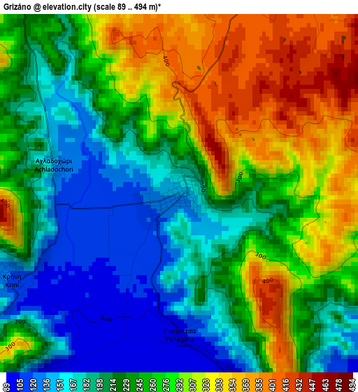
Below is the Elevation map of Grizáno, which displays elevation range with different colors. Scale of the first map is from 89 to 494 m (292 to 1621 ft) with average elevation of 248.6 meters (=816 ft) [note 1]
These maps also provides idea of topography and contour of this city, they are displayed at different zoom levels. More info about maps, scale and edge coordinates you can find below images.
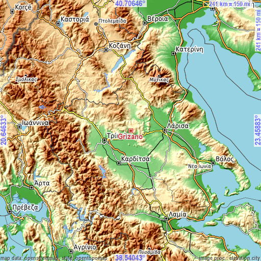
| \ | Map #1 | Topo.Map |
| Scale [m] | 89..494 m | × |
| Scale [ft] | 292..1621 ft | × |
| Average | 248.6 m = 816 ft | × |
| Width | 7.53 km = 4.7 mi | 240.8 km = 149.6 mi |
| Height | 7.53 km = 4.7 mi | 240.8 km = 149.6 mi |
| ↑Max Latitude | 39.665757° | 40.70646° |
| Latitude at center | 39.63192° | 39.63192° |
| ↓Min Latitude | 39.598067° | 38.54043° |
| ← Min Longitude | 22.008635° | 20.64633° |
| Longitude center | 22.05258° | 22.05258° |
| →Max Longitude | 22.096525° | 23.45883° |
Nearby cities:
Cities around Grizáno sort by population:
• Palamás elevation 92 m
18.6 km,  171°
171°
• Oichalía 106 m
6.8 km,  247°
247°
• Proástio 93 m
20.6 km,  218°
218°
• Verdikoússa 880 m
17.9 km,  338°
338°
• Megalochóri 104 m
19.7 km, 246°
• Zárkos 118 m
6.6 km,  113°
113°
• Itéa 97 m
21.8 km,  153°
153°
• Makrychóri 94 m
22.6 km,  199°
199°
• Taxiárches 96 m
15.1 km, 245°
• Palaiópyrgos 100 m
20.3 km,  262°
262°
• Agía Triáda 94 m
22.9 km, 215°
• Farkadóna 124 m
3.7 km,  161°
161°
Multilingual:
 En español:
Grizáno elevación 138 m.
 En France:
Grizáno élévation 138 m.


Sources and notes:
- [note 1] Map square and city borders are not equal. Map elevation data is calculated only from area inside that square.
- [src 1] Elevation data from geonames database provided with same terms of usage.
- [src 2] The elevation map of Grizáno is generated using elevation data from NASA's 3 arcsec (90m) resolution SRTM data.
- [src 3] Base (background) map © OpenStreetMap contributors tiles are generated by Geofabrik and OpenTopoMap.
Copyright & License:
This Grizáno Elevation Map is licensed under CC BY-SA. You may reuse any part from this page, if you give a proper credit by linking to this URL:
 More info on terms of use page.